Chicago
Chicago airport was our first stop on the way to the northwest of the United States to spend Thanksgiving night with Mark and Beverly Losh in Snohomish, supposedly the busiest airport in the world. There we ate the famous “Chicago’s Hot Dogs”: nothing extraordinary. I took the opportunity to polish my boots and to call Sharon. We took a long time to take our plane to San Francisco, California and left one of the suitcases behind. It was terrible. We had to go back to where we had lunch and, fortunately, we found it.
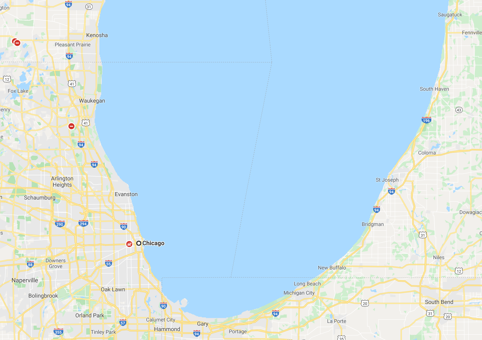
We already knew the Chicago airport, but this time we saw it renovated and impressive.
the City of Chicago is the most populous city in the U.S. state of Illinois and the third most populous city in the United States. With an estimated population of 2,705,994 (2018), it is also the most populous city in the Midwestern United States. Chicago is the county seat of Cook County, the second-most populous county in the US, with a small portion of the northwest side of the city extending into DuPage County near O’Hare Airport. Chicago is the principal city of the Chicago metropolitan area, often referred to as Chicagoland. At nearly 10 million people, the metropolitan area is the third-most populous in the United States.
Located on the shores of freshwater Lake Michigan, Chicago was incorporated as a city in 1837 near a portage between the Great Lakes and the Mississippi River watershed and grew rapidly in the mid-19th century. After the Great Chicago Fire of 1871, which destroyed several square miles and left more than 100,000 homeless, the city made a concerted effort to rebuild. The construction boom accelerated population growth throughout the following decades, and by 1900, less than 30 years after the great fire, Chicago was the fifth-largest city in the world. Chicago made noted contributions to urban planning and zoning standards, including new construction styles (including the Chicago School of architecture), the development of the City Beautiful Movement, and the steel-framed skyscraper.
Chicago is an international hub for finance, culture, commerce, industry, education, technology, telecommunications, and transportation. It is the site of the creation of the first standardized futures contracts, issued by the Chicago Board of Trade, which today is the largest and most diverse derivatives market in the world, generating 20% of all volume in commodities and financial futures alone. Depending on the particular year, the city’s O’Hare International Airport is routinely ranked as the world’s fifth or sixth busiest airport according to tracked data by the Airports Council International. The region also has the largest number of federal highways and is the nation’s railroad hub. Chicago was listed as an alpha global city by the Globalization and World Cities Research Network, and it ranked seventh in the entire world in the 2017 Global Cities Index. The Chicago area has one of the highest gross domestic products (GDP) in the world, generating $680 billion in 2017. In addition, the city has one of the world’s most diversified and balanced economies, with no single industry employing more than 14% of the workforce. Chicago is home to several Fortune 500 companies, including Allstate, Boeing, Exelon, Kraft Heinz, McDonald’s, Mondelez International, Sears, United Airlines Holdings, and Walgreens.
Chicago’s 58 million domestic and international visitors in 2018 made it the second most visited city in the nation, as compared with New York City’s 65 million visitors in 2018. The city was ranked first in the 2018 Time Out City Life Index, a global quality of life survey of 15,000 people in 32 cities. Landmarks in the city include Millennium Park, Navy Pier, the Magnificent Mile, the Art Institute of Chicago, Museum Campus, the Willis (Sears) Tower, Grant Park, the Museum of Science and Industry, and Lincoln Park Zoo. Chicago’s culture includes the visual arts, literature, film, theatre, comedy (especially improvisational comedy), food, and music, particularly jazz, blues, soul, hip-hop, gospel, and electronic dance music including house music. Of the area’s many colleges and universities, the University of Chicago, Northwestern University, and the University of Illinois at Chicago are classified as “highest research” doctoral universities. Chicago has professional sports teams in each of the major professional leagues, including two Major League Baseball teams.
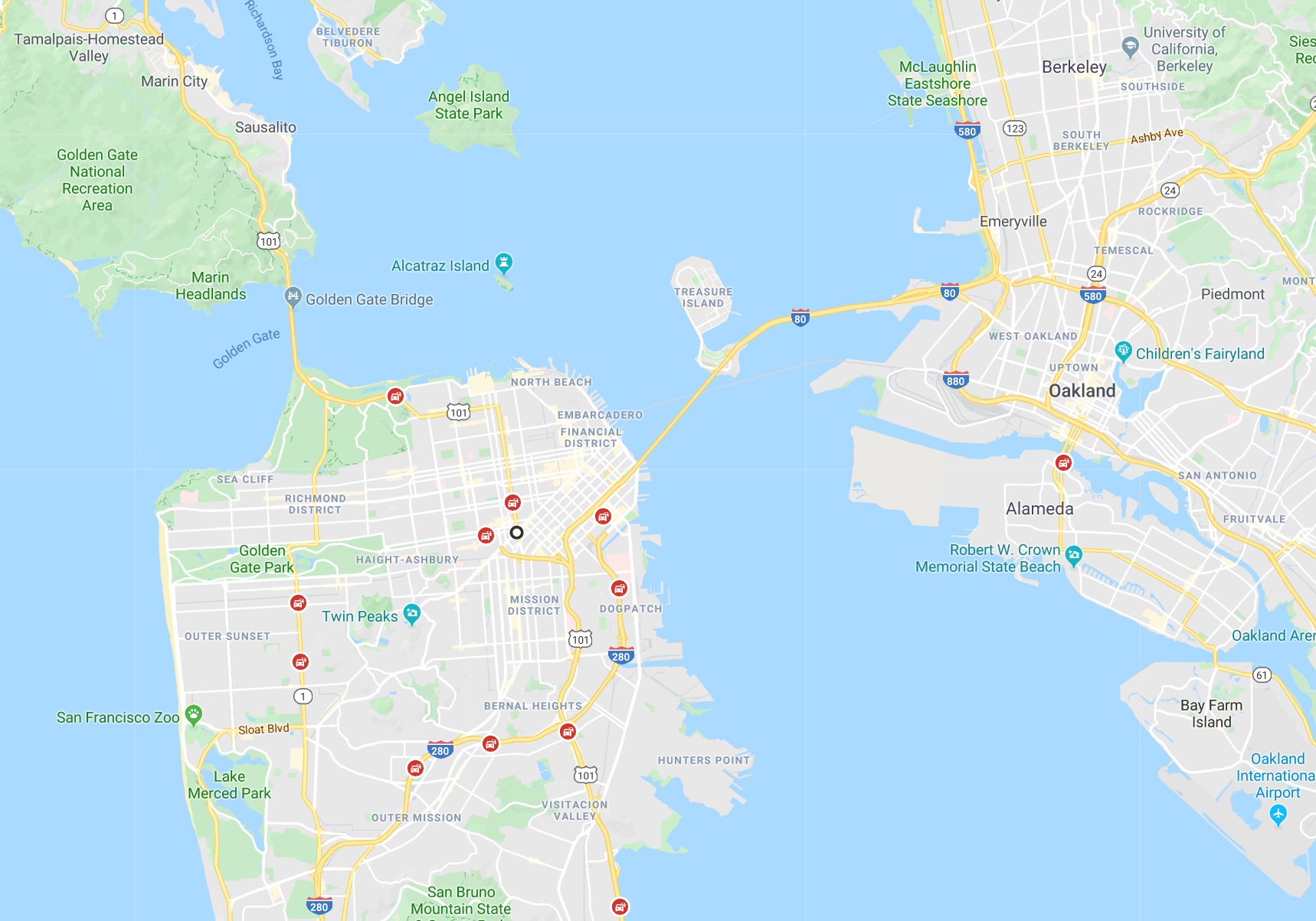
San Francisco
We took the opportunity to visit San Francisco, a city to which one always wants to return. The flight to San Francisco was terrible. The plane was full and we had to seat separately.
We stayed in a modest hotel near Chinatown. It was nice, but it could have been better.
In that hotel, breakfast was included. We had our first and last breakfast there.
The first time I visited San Francisco was in the company of Panino and his family (Milagros, Momy and Ricardo Eugenio). It was in December 1965 (52 years ago), just at the time when the Beatles made the song “Help” fashionable, one of my favorites.
On that occasion we traveled from Spokane to the city of San Leandro, to spend Christmas and New Year’s Eve with Milagros’ family, whose sister had recently arrived from Cuba. It was a wonderful experience and from that trip what I remember most was the visit to San Francisco Chinatown.
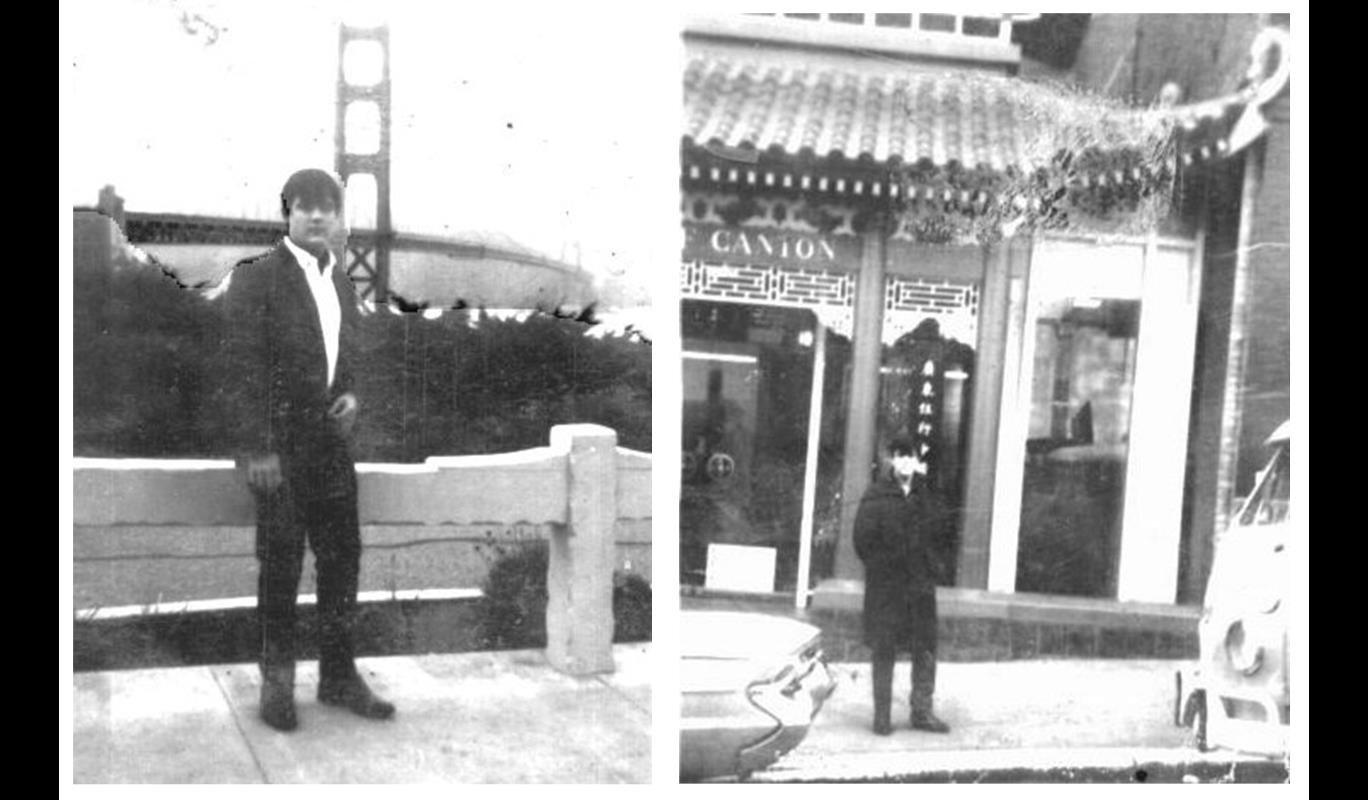
In the Golden Gate Bridge and China Town – San Francisco 1965
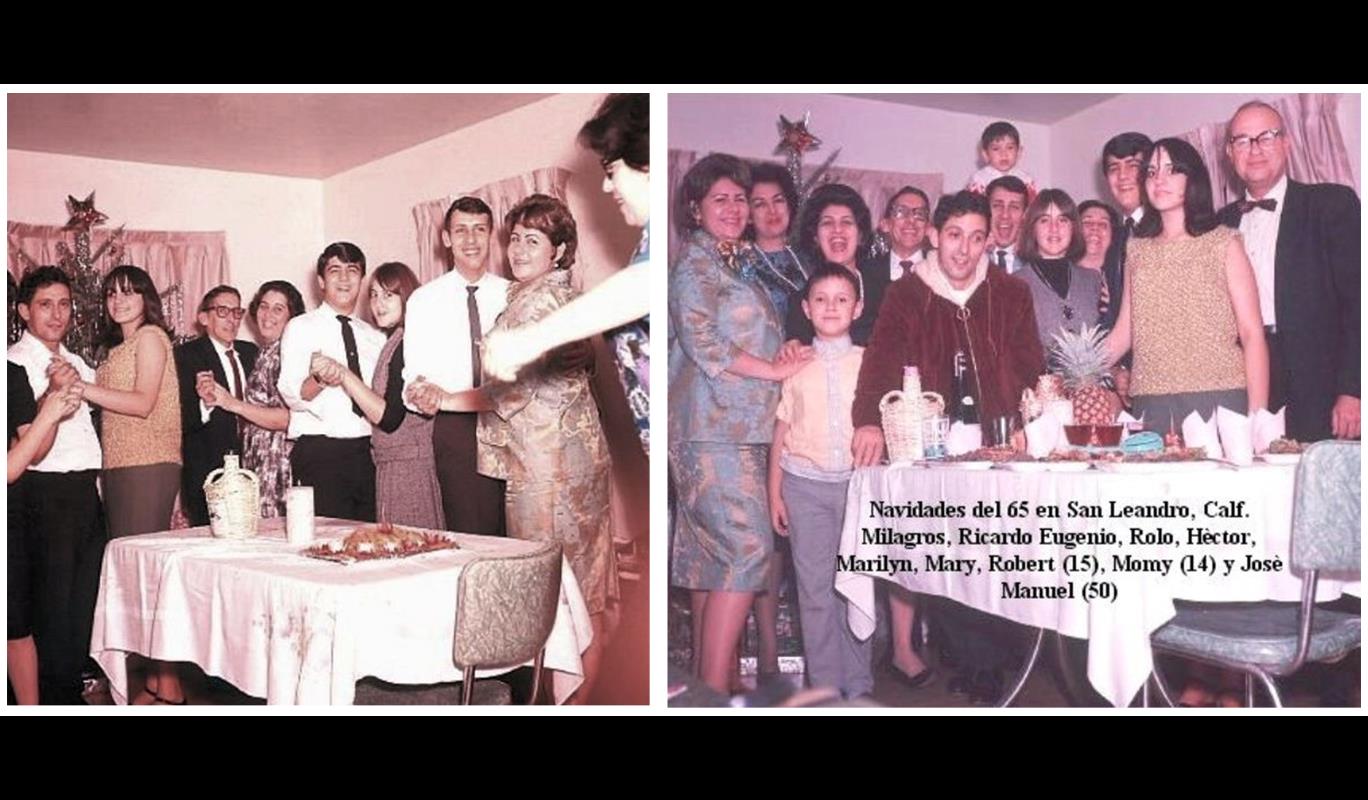
Celebrating Xmas with Milagro’s family in San Leandro, California – 1965
The second time I visited San Francisco was on our honeymoon, in 1974 (43 years ago). Of course, Siomi and I visited Chinatown, Fisherman Wharf, The Golden Gate Bridge, Lombard Street, etc.
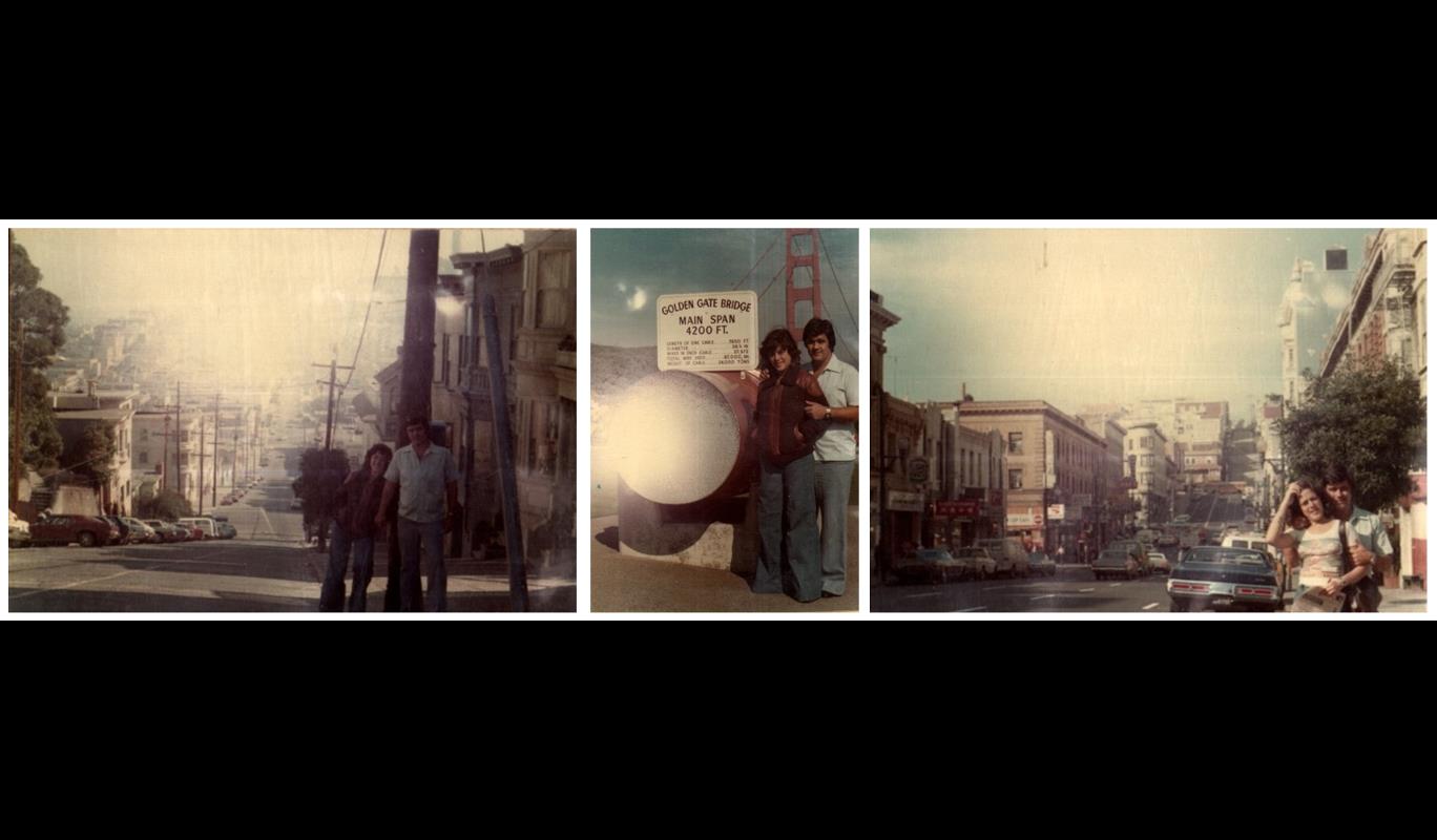
In 1974 – In the streets of San Francisco and visiting the Golden Gate Bridge
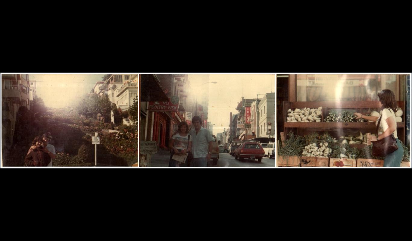
Visiting Lombard Street, San Francisco’s Chinatown and Siomi buying Chinese vegetables
This time we toured all the places that we had visited on our Honeymoon … and a few more places that did not exist then.
We took the “Big Bus” tour to the city …
The bus took us all over the city. There we met a couple of newly-married Asturians, who accompanied us on the tour. For them, it was the first time in San Francisco.
Height Ashbury
We visited the sector of what at one time (in the 60s) was the heart of the hippies of the world.
Haight-Ashbury is a district of San Francisco, California, named for the intersection of Haight and Ashbury streets. It is also called The Haight and The Upper Haight. The neighborhood is known for having been the birthplace of the hippie counterculture of the 1960s.
Before the completion of the Haight Street Cable Railroad in 1883, what is now the Haight-Ashbury was a collection of isolated farms and acres of sand dunes. The Haight cable car line, completed in 1883, connected the east end of Golden Gate Park with the geographically central Market Street line and the rest of downtown San Francisco. As the primary gateway to Golden Gate Park, and with an amusement park known as the Chutes on Haight Street between Cole and Clayton Streets between 1895 and 1902 and the California League Baseball Grounds stadium opening in 1887, the area became a popular entertainment destination, especially on weekends. The cable car, land grading and building techniques of the 1890s and early 20th century later reinvented the Haight-Ashbury as a residential upper-middle-class homeowners’ district. It was one of the few neighborhoods spared from the fires that followed the catastrophic San Francisco earthquake of 1906.
The mainstream media’s coverage of hippie life in the Haight-Ashbury drew the attention of youth from all over America. Hunter S. Thompson labeled the district “Hashbury” in The New York Times Magazine, and the activities in the area were reported almost daily. The Haight-Ashbury district was sought out by hippies to constitute a community based upon counterculture ideals, drugs, and music. This neighborhood offered a concentrated gathering spot for hippies to create a social experiment that would soon spread throughout the nation.
The first-ever head shop, Ron and Jay Thelin’s Psychedelic Shop, opened on Haight Street on January 3, 1966, offering hippies a spot to purchase marijuana and LSD, which was essential to hippie life in Haight-Ashbury. Along with businesses like the coffee shop The Blue Unicorn, the Psychedelic Shop quickly became one of the unofficial community centers for the growing numbers of freaks, heads, and hippies migrating to the neighborhood in 1966-67. The entire hippie community had easy access to drugs, which was perceived as a community unifier.
Another well-known neighborhood presence was the Diggers, a local “community anarchist” group known for its street theater, formed in the mid to late 1960s. One well-known member of the group was Peter Coyote. The Diggers believed in a free society and the good in human nature. To express their belief, they established a free store, gave out free meals daily, and built a free medical clinic, which was the first of its kind, all of which relied on volunteers and donations. The Diggers were strongly opposed to a capitalistic society; they felt that by eliminating the need for money, people would be free to examine their own personal values, which would provoke people to change the way they lived to better suit their character, and thus lead a happier life.
During the 1967 Summer of Love, psychedelic rock music was entering the mainstream, receiving more and more commercial radio airplay. The Scott McKenzie song “San Francisco (Be Sure to Wear Flowers in Your Hair),” became a hit that year. The Monterey Pop Festival in June further cemented the status of psychedelic music as a part of mainstream culture and elevated local Haight bands such as the Grateful Dead, Big Brother and the Holding Company, and Jefferson Airplane to national stardom. A July 7, 1967, Time magazine cover story on “The Hippies: Philosophy of a Subculture,” an August CBS News television report on “The Hippie Temptation” and other major media interest in the hippie subculture exposed the Haight-Ashbury district to enormous national attention and popularized the counterculture movement across the country and around the world.
The neighborhood’s fame reached its peak as it became the haven for a number of psychedelic rock performers and groups of the time. The members of Jefferson Airplane, the Grateful Dead, and Janis Joplin, all lived close to the intersection. They not only immortalized the scene in the song but also knew many within the community.
The Summer of Love attracted a wide range of people of various ages: teenagers and college students drawn by their peers and the allure of joining a cultural utopia; middle-class vacationers; and even partying military personnel from bases within driving distance. The Haight-Ashbury could not accommodate this rapid influx of people, and the neighborhood scene quickly deteriorated. Overcrowding, homelessness, hunger, drug problems, and crime afflicted the neighborhood. Many people left in the autumn to resume their college studies. On October 6, 1967, those remaining in the Haight staged a mock funeral, Digger happening, “The Death of the Hippie” ceremony. Mary Kasper explained the message of the mock funeral as:
We wanted to signal that this was the end of it, don’t come out. Stay where you are! Bring the revolution to where you live. Don’t come here because it’s over and done with.
After 1968, the area went into decline due to hard drug use, and a lack of policing, but was improved and renewed in the late 1970s. The Haight Ashbury was the origin of several communities and movements, including The Farm and the Rainbow Family. The Haight was at one point the home to hundreds of intentional communities, although few lasted and many moved outside the area. The last hippie commune with a continuous presence there may have been Kerista Commune.
In the 1980s, the Haight became an epicenter for the San Francisco comedy scene when a small coffee house off Haight Street called The Other Café at 100 Carl Street (currently the restaurant Crepes on Cole) became a full-time comedy club that helped launch the careers of Robin Williams, Dana Carvey, and Whoopi Goldberg. From the 1980s to the early 1990s, the I-Beam nightclub on Haight Street became a hotspot for modern rock dance music in San Francisco, and a popular venue for live performances by new wave, punk, industrial and indie bands.
Pier 39
We didn’t know Fisherman Wharf’s Pier No. 39. There we had extraordinary seafood.
We toured the place to meet the sea lions that have made their habitat in the rafts of that already-famous pier. No one knows why they chose that place.
We also visited a great store where they sell Swiss chocolate. There is NOT a single type of Swiss chocolate that is not sold in that store
We even saw the Devil walking around Pier 39
Pier 39 is a shopping center and popular tourist attraction built on a pier in San Francisco, California. At Pier 39, there are shops, restaurants, a video arcade, street performances, the Aquarium of the Bay, virtual 3D rides, and views of California sea lions hauled out on docks on Pier 39’s marina. A two-story carousel is one of the pier’s more dominant features, although it is not directly visible from the street and sits towards the end of the pier. The family-oriented entertainment and presence of marine mammals make this a popular tourist location for families with kids.
The pier is located at the edge of the Fisherman’s Wharf district and is close to North Beach, Chinatown, and the Embarcadero. The area is easily accessible with the historic F Market streetcars.
From the pier, one can see Angel Island, Alcatraz Island, the Golden Gate Bridge, and the Bay Bridge. Blue & Gold Fleet’s bay cruises leave from Pier 39
Pier 39 was first developed by entrepreneur Warren Simmons and opened on October 4, 1978.
On December 22, 2017, the Federal Bureau of Investigation arrested Everitt Aaron Jameson, a 25-year-old former Marine, on suspicion of planning a terrorist attack in the Pier 39 area over Christmas.
California sea lions have always been present in San Francisco Bay. They started to haul out on docks of Pier 39 in September 1989. Before that, they mostly used Seal Rock for that purpose. Ever since September 1989, the number of sea lions on Seal Rock has been steadily decreasing, while their number on Pier 39 has generally increased. Some people speculate that sea lions moved to docks because of the 1989 Loma Prieta earthquake, but the earthquake occurred months after the first sea lions had arrived at Pier 39. It is likely that the sea lions feel safer inside the Bay.
The Bay Ecotarium/ Bay.org (501c-3)non-profit largest watershed conservation group in the Bay Area, operates the Sea Lion Center as an extended education arm of the Aquarium of the Bay on Pier #39. Naturalists and education staff interact with visitors and school groups with programs and demonstration activities. According to President & CEO George Jacob, plans are afoot to celebrate the 30th anniversary of the arrival of sea lions in 2020.
Although the reason for their migration to the pier is unclear, the refurbishing of the docks in September 1989 required the removal of all boats from that area, leaving large open spaces for the sea lions to move into. Once the project was completed, boat owners returned, but did their best to navigate around the sea lions; no efforts were made to encourage the new guests to leave. By the end of that year, fewer than a dozen sea lions frequented the docks at Pier 39. By January 1990, their numbers had increased to 150 animals. Owners of the 11 boats docked there began to complain about having to avoid the animals who can weigh up to half a ton, and odor and noise complaints began to pour in. News coverage caught national attention, and the sea lions began to attract tourists. Advice from The Marine Mammal Center was to abandon the docks to the animals and to relocate the boats elsewhere.
Although fluctuations in the number of sea lions at Pier 39 are dramatic, as many as 1,701 (Thanksgiving Week, 2009) have been officially reported at one time, many of whom are recognizable to researchers and others, and some of whom have been unofficially named. Volunteers and staff at The Marine Mammal Store and Interpretive Center monitor the sea lion population each day, and educational information is provided to tourists who visit from around the world. Scientists continue to collect information there, adding to knowledge about sea lion health, dietary habits, and behavior. In November 2009 the more than 1,701 (Thanksgiving Week, 2009) sea lions that had lived at the pier began to leave, and by late December 2009 nearly all were gone; a similar flux in population occurs annually, with the animals returning in the spring. Although the reason for their seasonal appearance and departure is not known for certain, according to Jeff Boehm, executive director of the Marine Mammal Center in Sausalito, “Most likely, they left chasing a food source,” anchovies and sardines. A handful of sea lions did return in February, and by late May several hundred could once again be seen on Pier 39. It remains unknown exactly where they went and why. However, in December 2009, nearly 4,000 sea lions that were identified as members of the California sub-species were seen outside Oregon’s Sea Lion Caves, suggesting that they were likely the sea lions from Pier 39.
In early 2017, the estimated number of seals ranged from 150 to 600 around the pier. In June and July however, most were expected to leave temporarily for their breeding grounds near the Channel Islands.
Fisherman Wharf
On our Honeymoon, 43 years ago, this place was very different. We found it totally changed.
Photo of our honeymoon
There we had an extraordinary cheese soup. The place has grown to favor the tourism industry. When we visited Fisherman Wharf for the first time, in 1974, it was more “artisanal”. It was the place where fishermen’s boats docked. Today is something else, but it is worth visiting.
Fisherman’s Wharf is a neighborhood and popular tourist attraction in San Francisco, California. It roughly encompasses the northern waterfront area of San Francisco from Ghirardelli Square or Van Ness Avenue east to Pier 35 or Kearny Street. The F Market streetcar runs through the area, the Powell-Hyde cable car lines run to Aquatic Park, at the edge of Fisherman’s Wharf, and the Powell-Mason cable car line runs a few blocks away.
San Francisco’s Fisherman’s Wharf gets its name and neighborhood characteristics from the city’s early days of the mid to later 1800s when Italian immigrant fishermen came to the city by the bay to take advantage of the influx of population due to the gold rush. One, Achille Paladini, found success wholesaling local fish as the owner of the Paladini Fish Company, and came to be known as the “Fish King”. Most of the Italian immigrant fishermen settled in the North Beach area close to the wharf and fished for the local delicacies and the now famed Dungeness crab. From then until the present day it remained the home base of San Francisco’s fishing fleet. Despite its redevelopment into a tourist attraction during the 1970s and 1980s, the area is still home to many active fishermen and their fleets.
In 2010, a $15 million development plan was proposed by city officials hoping to revitalize its appearance for tourists, and to reverse the area’s downward trend in popularity among San Francisco residents, who have shunned the locale over the years.
One of the busiest and well-known tourist attractions in the western United States, Fisherman’s Wharf is best known for being the location of Pier 39, the Cannery Shopping Center, Ghirardelli Square, a Ripley’s Believe it or Not museum, the Musée Mécanique, Wax Museum at Fishermans Wharf, and the San Francisco Maritime National Historical Park.
Seafood restaurants are plentiful in the area. Some include the floating Forbes Island restaurant at Pier 39 to stands that serve fresh seafood, most notably Dungeness crab and clam chowder served in a sourdough bread bowl. Some of the restaurants, including Fishermen’s Grotto, Pompei’s Grotto and Alioto’s, go back for three generations of the same family ownership. Other restaurants include chains like Applebee’s and Bubba Gump Shrimp Co. The area also has an In-N-Out Burger; local business leaders said they opposed every other fast-food chain except In-N-Out, because they wanted to maintain the flavor of family-owned, decades-old businesses in the area, with one saying locals would ordinarily “be up in arms about a fast-food operation coming to Fisherman’s Wharf,” but the family-owned In-N-Out “is different.”
Other attractions in Fisherman’s Wharf area are the Hyde Street Pier (part of the San Francisco Maritime National Historical Park), the USS Pampanito, a decommissioned World War II-era submarine, and the Balclutha, a 19th-century cargo ship. Nearby Pier 45 has a chapel in memory of the “Lost Fishermen” of San Francisco and Northern California.
There is a sea lion colony next to Pier 39. They “took-up” residence months before the Loma Prieta earthquake in 1989. The sea lions lie on wooden docks that were originally used for docking boats.
Fisherman’s Wharf plays host to many San Francisco events, including a world-class fireworks display for Fourth of July, and some of the best views of the Fleet Week air shows featuring The Blue Angels.
The USS Pampanito (SS-383) and SS Jeremiah O’Brien are National Historic Landmarks, preserved as a memorial and museum ships as part of the San Francisco Maritime National Park Association located at the Wharf.
Golden Gate Bridge
During our Honeymoon, we visit the Golden Gate Bridge, a must for every tourist, but this time we find its surroundings completely changed. There we take videos and many photos.
Near the Golden Gate Bridge is the Golden Gate Park, a place everybody has to visit in San Francisco
The Golden Gate Bridge is a suspension bridge spanning the Golden Gate, the one-mile-wide (1.6 km) strait connecting San Francisco Bay and the Pacific Ocean. The structure links the American city of San Francisco, California—the northern tip of the San Francisco Peninsula—to Marin County, carrying both U.S. Route 101 and California State Route 1 across the strait. The bridge is one of the most internationally recognized symbols of San Francisco, California, and the United States. It has been declared one of the Wonders of the Modern World by the American Society of Civil Engineers.
The Frommer’s travel guide describes the Golden Gate Bridge as “possibly the most beautiful, certainly the most photographed, bridge in the world.” At the time of its opening in 1937, it was both the longest and the tallest suspension bridge in the world, with a main span of 4,200 feet (1,280 m) and a total height of 746 feet (227 m).
Before the bridge was built, the only practical short route between San Francisco and what is now Marin County was by boat across a section of San Francisco Bay. A ferry service began as early as 1820, with a regularly scheduled service beginning in the 1840s for the purpose of transporting water to San Francisco.
The Sausalito Land and Ferry Company service, launched in 1867, eventually became the Golden Gate Ferry Company, a Southern Pacific Railroad subsidiary, the largest ferry operation in the world by the late 1920s. Once for railroad passengers and customers only, Southern Pacific’s automobile ferries became very profitable and important to the regional economy. The ferry crossing between the Hyde Street Pier in San Francisco and Sausalito Ferry Terminal in Marin County took approximately 20 minutes and cost $1.00 per vehicle, a price later reduced to compete with the new bridge. The trip from the San Francisco Ferry Building took 27 minutes.
Many wanted to build a bridge to connect San Francisco to Marin County. San Francisco was the largest American city still served primarily by ferry boats. Because it did not have a permanent link with communities around the bay, the city’s growth rate was below the national average. Many experts said that a bridge could not be built across the 6,700-foot (2,000-metre) strait, which had strong, swirling tides and currents, with water 372 ft (113 m) deep at the center of the channel, and frequent strong winds. Experts said that ferocious winds and blinding fogs would prevent construction and operation.
Chinatown
For me, it was the third time I visited the Chinatown of San Francisco. The first time was in the company of Panino and family, in December 1965, when he was 15 years old: 52 years ago!
In 1974 we spent part of our Honeymoon in San Francisco and, of course, we visited the Chinatown, where Siomi had fun buying vegetables.
Of course, everything has changed a lot. Now the neighborhood is more tourism-oriented, however, it is worth visiting although it was unrecognizable to us.
Photo with Siomi in the streets of Chinatown
We went back to Chinatown, a magical sector of San Francisco. In our Honeymoon, we spent a few days with the Chinese. We tried to visit the same places, but it was impossible. Everything has changed a lot. But in our mind, we went back to where we were 43 years back. The first night we spent in San Francisco, we wanted to eat real Chinese food as we did 43 years ago, but we didn’t have any luck. We went to the most-recommended Chinese restaurant in Chinatown, according to Google, and it was no good at all.
We went back to Chinatown, a magical sector of San Francisco. In our Honeymoon, we spent few days with the Chinese. We tried to visit the same places, but it was impossible. Everything has changed a lot. But in our mind, we went back to where we were 43 years back.

Siomi buying vegetables in 1974 and in 2017. How about that?
Of course, Siomi insisted on buying Chinese vegetables, but this time it didn’t overwhelm our enthusiasm.
We made other purchases. There we bought a very functional suitcase that accompanied us throughout the trip until we returned to Florida. We also bought Miranda a Chinese dress.
We were surprised to see a Catholic church in the Chinatown of San Francisco and we visited it.
The Chinatown centered on Grant Avenue and Stockton Street in San Francisco, California, (Chinese: 唐人街; pinyin: tángrénjiē; Jyutping: tong4 jan4 gaai1) is the oldest Chinatown in North America and one of the largest Chinese enclaves outside Asia. It is also the oldest and largest of the four notable Chinese enclaves within San Francisco. Since its establishment in 1848, it has been highly important and influential in the history and culture of ethnic Chinese immigrants in North America. Chinatown is an enclave that continues to retain its own customs, languages, places of worship, social clubs, and identity. There are two hospitals, several parks and squares, numerous churches, a post office, and other infrastructure. Recent immigrants, many of whom are elderly, opt to live in Chinatown because of the availability of affordable housing and their familiarity with the culture. San Francisco’s Chinatown is also renowned as a major tourist attraction, drawing more visitors annually than the Golden Gate Bridge.
San Francisco’s Chinatown was the port of entry for early Chinese immigrants from the west side of the Pearl River Delta, speaking mainly Hoisanese and Zhongshanese, in the Guangdong province of southern China from the 1850s to the 1900s. On August 28, 1850, at Portsmouth Square,:9 San Francisco’s first mayor, John Geary, officially welcomed 300 “China Boys” to San Francisco.:34–38 By 1854, the Alta California, a local newspaper which had previously taken a supportive stance on Chinese immigrants in San Francisco, began attacking them, writing after a recent influx that “if the city continues to fill up with these people, it will be here long become necessary to make them subject of special legislation”.
These early immigrants settled near Portsmouth Square and around Dupont Street (now called Grant Ave). :54–55 As the settlement grew in the early 1850s, Chinese shops opened on Sacramento St, which the Guangdong pioneers called “Tang people street” (唐人街); 13 and the settlement became known as “Tang people town” (唐人埠), which in Cantonese is Tong Yun Fow.: 9–40 By the 1870s, the economic center of Chinatown moved from Sacramento St to Dupont St; 15–16 e.g., in 1878, out of 423 Chinese firms in Chinatown, 121 were located on Dupont St, 60 on Sacramento St, 60 on Jackson St, and the remainder elsewhere. :15
The area was the one geographical region deeded by the city government and private property owners which allowed Chinese persons to inherit and inhabit dwellings within the city. The majority of these Chinese shopkeepers, restaurant owners, and hired workers in San Francisco Chinatown were predominantly Hoisanese and male. For example, in 1851, the reported Chinese population in California was about 12,000 men and less than ten women.:41 Some of the early immigrants worked as mine workers or independent prospectors hoping to strike it rich during the 1849 Gold Rush. Many Chinese found jobs working for large companies seeking a source of labor, most famously as part of the Central Pacific on the Transcontinental Railroad, from 1865–1869.
Lombard Street
It is a must-see place for all tourists who pass through San Francisco. It is known as the curviest street in the world. We don’t know how those who live in that small street do. We had already visited it on our Honeymoon.
This time we found her the same as when we met her 43 years before. We were surprised by how many tourists were in it.
Lombard Street is an east-west street in San Francisco, California that is famous for a steep, one-block section with eight hairpin turns. Stretching from The Presidio east to The Embarcadero (with a gap on Telegraph Hill), most of the street’s western segment is a major thoroughfare designated as part of U.S. Route 101. The famous one-block section claimed to be “the most crooked street in the world”, is located along the eastern segment in the Russian Hill neighborhood. It is a major tourist attraction, receiving around two million visitors per year and up to 17,000 per day on busy summer weekends, as of 2015.
San Francisco surveyor Jasper O’Farrell named the road after Lombard Street in Philadelphia.
Lombard Street’s west end is at Presidio Boulevard inside The Presidio; it then heads east through the Cow Hollow neighborhood. For 12 blocks, between Broderick Street and Van Ness Avenue, it is an arterial road that is co-signed as U.S. Route 101. Lombard Street continues through the Russian Hill neighborhood and to the Telegraph Hill neighborhood. At Telegraph Hill it turns south, becoming Telegraph Hill Boulevard to Pioneer Park and Coit Tower. Lombard Street starts again at Winthrop Street and ends at The Embarcadero as a collector road.
Lombard Street is known for the one-way block on Russian Hill between Hyde and Leavenworth Streets, where eight sharp turns are said to make it the most crooked street in the world. The design, first suggested by property owner Carl Henry and built-in 1922, was intended to reduce the hill’s natural 27 percent grade, which was too steep for most vehicles. The crooked block is about 600 feet (180 m) long (412.5 feet (125.7 m) straight line), is one-way (downhill) and is paved with red bricks. The sign at the top recommends 5 mph (8 km/h).
The segment normally sees around 250 vehicles per hour, with average daily traffic reaching 2630 vehicles in 2013. During peak times, vehicles have to wait up to 20 minutes to enter the Crooked Street segment, in a queue that can reach Van Ness Avenue. To reduce habitual congestion and delays, future visitors may be required to reserve a time and pay a fee to drive down the crooked street.
The Powell-Hyde cable car stops at the top of the block on Hyde Street.
By 2017, the area around the curved segment had become a hot-spot of what has been described as “San Francisco’s car break-in epidemic.”
The Academy of Art University owns and operates a building called Star Hall on the street for housing purposes.
Past residents of Lombard Street include Rowena Meeks Abdy, an early California painter who worked in the style of Impressionism.
Chase scenes in many films have been filmed on the street, including Good Neighbor Sam, Dr. Goldfoot and the Bikini Machine, What’s Up, Doc?, Magnum Force, and Ant-Man and the Wasp. Lombard Street is also portrayed in the 2015 Pixar film Inside Out.
Sushi
It was in San Francisco where we tried sushi when we visited it on our Honeymoon. The night before saying goodbye to San Francisco, we had dinner at a Japanese restaurant and we were pleased with a large amount of sushi they served us.
Sushi is a Japanese dish of prepared vinegared rice (鮨飯 sushi-meshi), usually with some sugar and salt, accompanying a variety of ingredients (ネタ neta), such as seafood, vegetables, and occasionally tropical fruits. Styles of sushi and its presentation vary widely, but the one key ingredient is “sushi rice”, also referred to as shari (しゃり), or sumeshi (酢飯).
Sushi is traditionally made with medium-grain white rice, though it can be prepared with brown rice or short-grain rice. It is very often prepared with seafood, such as squid, eel, yellowtail, salmon, tuna or imitation crab meat. Many types of sushi are vegetarian. It is often served with pickled ginger (gari), wasabi, and soy sauce. Daikon radish or pickled daikon (takuan) are popular garnishes for the dish.
Sushi is sometimes confused with sashimi, a related dish in Japanese cuisine that consists of thinly sliced raw fish, or occasionally meat, and an optional serving of rice.
Our last night in San Francisco we went to the bay to see the SWOAT Team, a bunch of crazy people that swim every night, regardless of the weather. That night was very-very cold, and they were swimming like it was summer.
We also spent that last night taking videos of our favorite places. We were excited about getting North, but sad that we had to leave San Francisco, maybe for good.
City and County of San Francisco and colloquially known as SF, San Fran, or “The City”, is the cultural, commercial, and financial center of Northern California. San Francisco is the 13th-most populous city in the United States, and the fourth-most populous in California, with 883,305 residents as of 2018. It covers an area of about 46.89 square miles (121.4 km2), mostly at the north end of the San Francisco Peninsula in the San Francisco Bay Area, making it the second-most densely populated large U.S. city, and the fifth-most densely populated U.S. county, behind only four of the five New York City boroughs. San Francisco is the 12th-largest metropolitan statistical area in the United States, with 4,729,484 people in 2018. With San Jose, it forms the fifth-most populous combined statistical area in the United States, the San Jose–San Francisco–Oakland, CA Combined Statistical Area (9.67 million residents in 2018).
As of 2018, it was the seventh-highest income county in the United States, with a per capita personal income of $130,696. As of 2015, San Francisco proper had a GDP of $154.2 billion, and a GDP per capita of $178,479. The CSA San Francisco shares with San Jose and Oakland was the country’s third-largest urban economy as of 2017, with a GDP of $907 billion. Of the 500+ primary statistical areas in the U.S., this CSA had among the highest GDP per capita in 2017, at $93,938. San Francisco was ranked 16th in the world and third in the United States on the Global Financial Centres Index as of March 2019.
San Francisco was founded on June 29, 1776, when colonists from Spain established Presidio of San Francisco at the Golden Gate and Mission San Francisco de Asís a few miles away, all named for St. Francis of Assisi. The California Gold Rush of 1849 brought rapid growth, making it the largest city on the West Coast at the time. San Francisco became a consolidated city-county in 1856. San Francisco’s status as the West Coast’s largest city peaked between 1870 and 1900 when around 25% of California’s population resided in the city proper. After three-quarters of the city was destroyed by the 1906 earthquake and fire, San Francisco was quickly rebuilt, hosting the Panama-Pacific International Exposition nine years later. In World War II, San Francisco was a major port of embarkation for service members shipping out to the Pacific Theater. It then became the birthplace of the United Nations in 1945. After the war, the confluence of returning servicemen, significant immigration, liberalizing attitudes, along with the rise of the “hippie” counterculture, the Sexual Revolution, the Peace Movement growing from opposition to United States involvement in the Vietnam War, and other factors led to the Summer of Love and the gay rights movement, cementing San Francisco as a center of liberal activism in the United States. Politically, the city votes strongly along liberal Democratic Party lines.
A popular tourist destination, San Francisco is known for its cool summers, fog, steep rolling hills, eclectic mix of architecture, and landmarks, including the Golden Gate Bridge, cable cars, the former Alcatraz Federal Penitentiary, Fisherman’s Wharf, and its Chinatown district. San Francisco is also the headquarters of five major banking institutions and various other companies such as Levi Strauss & Co., Gap Inc., Fitbit, Salesforce.com, Dropbox, Reddit, Square, Inc., Dolby, Airbnb, Weebly, Pacific Gas and Electric Company, Yelp, Pinterest, Twitter, Uber, Lyft, Mozilla, Wikimedia Foundation, Craigslist, and Weather Underground. The city, and the surrounding Bay Area, is a global center of the sciences and arts and is home to a number of educational and cultural institutions, such as the University of San Francisco (USF), University of California, San Francisco (UCSF), San Francisco State University (SFSU), the De Young Museum, the San Francisco Museum of Modern Art, the SFJAZZ Center, and the California Academy of Sciences.
As of 2019, San Francisco is the highest-rated American city on world liveability rankings.
Sausalito
For the first time, we visited this small town near San Francisco, where Clint Eastwood was mayor. A place worth visiting. There I bought excellent third-dimensional binoculars which I used the rest of the trip.
Sausalito is a city in Marin County, California, located 8 miles (13 km) south-southeast of San Rafael and 4 miles (7 km) north of San Francisco.
Sausalito’s population was 7,061 as of the 2010 census. The community is situated near the northern end of the Golden Gate Bridge, and prior to the building of that bridge served as a terminus for rail, car, and ferry traffic.
Sausalito developed rapidly as a shipbuilding center in World War II, with its industrial character giving way in postwar years to a reputation as a wealthy and artistic enclave, a picturesque residential community (incorporating large numbers of houseboats), and a tourist destination. The city is adjacent to and largely bounded by, the protected spaces of the Golden Gate National Recreation Area.
Sausalito was once the site of a Coast Miwok settlement known as Liwanelowa. The branch of the Coast Miwok living in this area was known as the Human (or as Nación de Uimen to the Spanish). Early explorers of the area described them as friendly and hospitable. According to Juan de Ayala, “To all these advantages must be added the best of all, which is that the heathen Indians of the port are so faithful in their friendship and so docile in their disposition that I was greatly pleased to receive them on board.” Such placidity was likely a contributing factor to their complete displacement, which took place within the span of a few generations. As historian Jack Tracy has observed, “Their dwellings on the site of Sausalito were explored and mapped in 1907, nearly a century and a half later, by an archaeological survey. By that time, nothing was left of the culture of those who had first enjoyed the natural treasures of the bay. The life of the Coastal Miwoks had been reduced to archaeological remnants, as though thousands of years had passed since their existence.”
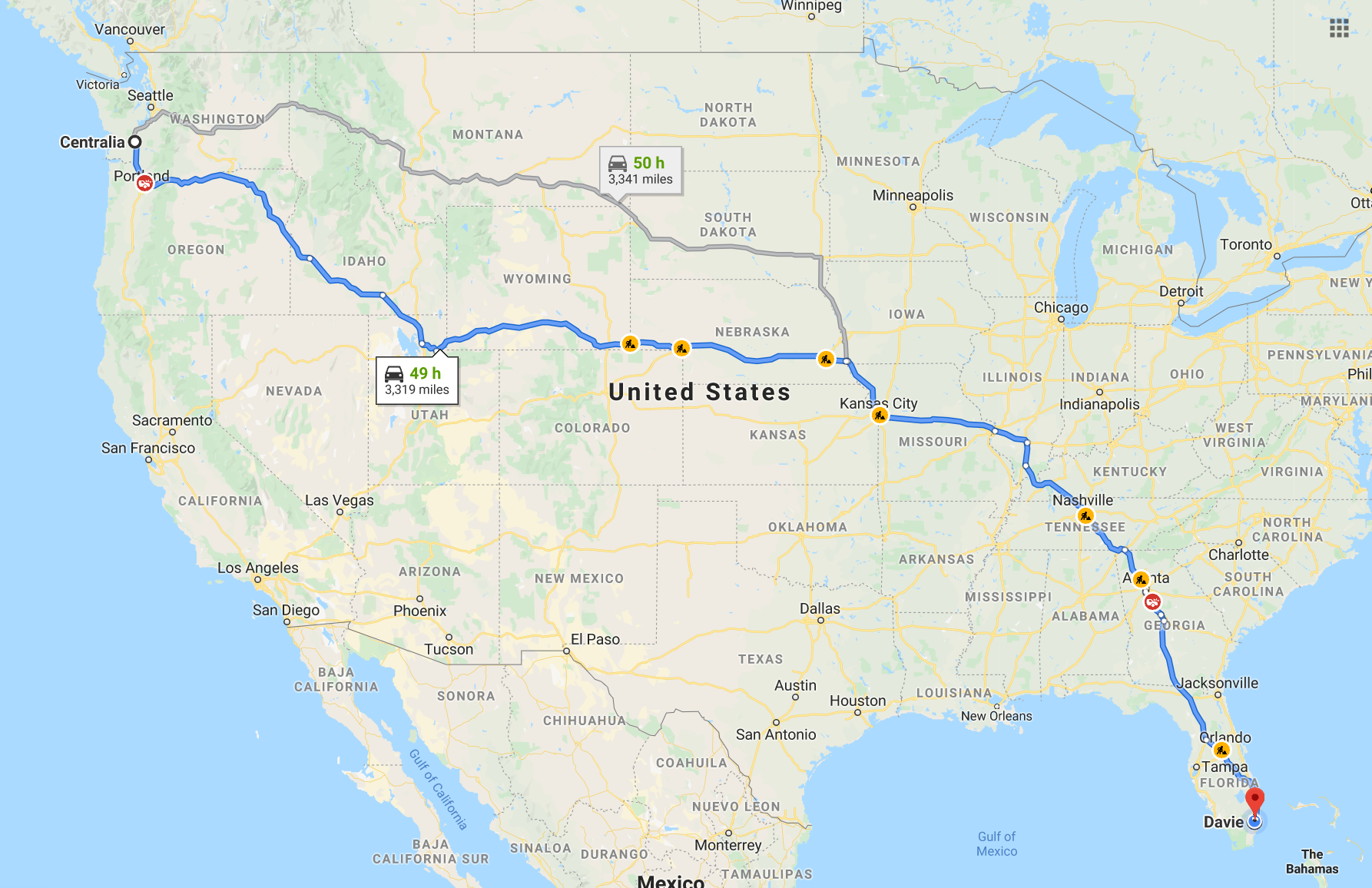
Centralia
From the Portland airport, in the state of Oregon, we headed to the town of Centralia, where Beverly lived, who we had to take to Snohomish to spend with Thanksgiving his son Mark. Beverly was living in a senior community. A very beautiful and well-maintained place. His two-room apartment was comfortable and functional.
We spend the night at Beverly’s house. He had brought holy water to “bless” Mark’s house and scare away all the demons that might be there.
Centralia (/sɛnˈtreɪliə/) is a city in Lewis County, Washington, United States. The population was 16,336 at the 2010 census.
In the 1850s and 1860s, Centralia’s Borst Home, at the confluence of the Chehalis and Skookumchuck Rivers, was the site of a toll ferry, and the halfway stopping point for stagecoaches operating between Kalama, Washington, and Tacoma. In 1850, J. G. Cochran and his wife Anna were led there via the Oregon Trail by their adopted son, George Washington, a free African-American. The family feared Washington would be forced into slavery if they stayed in Missouri after the passage of the Compromise of 1850. Cochran filed a donation land claim near the Borst Home in 1852 and was able to sell his claim to Washington for $6,000 because unlike the neighboring Oregon Territory, there was no restriction against passing legal ownership of land to African Americans in the newly formed Washington Territory.
Upon hearing of the imminent arrival of the Northern Pacific Railway (NP) in 1872, Washington and his wife, Mary Jane, filed a plat for the town of Centerville, naming the streets after biblical references and offering lots for $10 each, with one lot free to buyers who built houses. Washington also donated land for a city park, a cemetery, and a Baptist church. Responding to new settlers’ concerns about a town in Klickitat County with the same name, the town was renamed Centralia by 1883, as suggested by a recent settler from Centralia, Illinois, and officially incorporated on February 3, 1886. The town’s population boomed, then collapsed in the Panic of 1893, when the NP went bankrupt; entire city blocks were offered for as little as $50 with no takers. Washington (despite facing racial prejudice from some newcomers) made personal loans and forgave debt to keep the town afloat until the economy stabilized; the city then boomed again based on the coal, lumber and dairying industries. When Washington died in 1905, all businesses in the town closed, and 5,000 mourners attended his funeral.
The boom lasted until November 11, 1919, when the infamous Centralia Massacre occurred. Spurred on by local lumber barons, American Legionnaires (many of whom had returned from WWI to find their jobs filled by pro-union members of the Industrial Workers of the World (IWW)), used the Armistice Day parade to attack the IWW hall. Marching with loaded weapons, the Legionnaires broke from the parade and stormed the hall in an effort to bust union organizing efforts by what was seen to be a Bolshevik-inspired labor movement. Though it remains a point of controversy as to who fired first, IWW workers including recently returned WWI veteran Wesley Everest, stood their ground, engaging and killing four Legionnaires. Everest was captured, jailed and then brutally lynched. Other IWW members were also jailed. The event made international headlines, and coupled with similar actions in Everett, Washington and other lumber towns, stifled the American labor movement until the economic devastation of the 1930s Great Depression changed opinions about labor organizations.
The town’s name was originally a reference to the town’s location as the midway point between Tacoma and Kalama (which were originally the NP’s Washington termini), but proved to have longevity when it became the midpoint between Seattle and Portland, Oregon as well during the development of Washington’s I-5 portion of the Interstate Highway System. As extractive industries faced decline, Centralia’s development refocused on freeway oriented food, lodging, retail and tourism, as well as regional shipping and warehousing facilities, leading to 60% population growth over the past four decades.
Shari’s
At Shari’s we had lunch with Beverly. We did not know the place since it is a chain that is only known in the northwestern United States.
Shari’s Cafe & Pies, originally known as Shari’s Restaurants, is a chain of family dining restaurants in the western United States. Open 24 hours a day, 365 days a year, the franchise’s original restaurant was opened in Hermiston, Oregon in 1978. As of August 2017, the company operated 95 locations in the states of Oregon, Washington, California, Idaho, Nebraska, and Wyoming. Shari’s features a distinctive hexagonal building design for most of its restaurant locations. Its corporate offices are located in the Progress area of Beaverton.
Shari’s began in Hermiston, Oregon in 1978 with Ron and Sharon Bergquist as proprietors. The two ran the company for seven years. By 1999, Shari’s was the ninth largest family restaurant chain in the United States based on total sales, and sixth in growth.
In March 1999, the chain was acquired by Fairmont Capital Inc. for $60 million. At that time Shari’s operated 96 locations in seven states with 4,000 employees and $128 million in annual revenue. They were still the ninth largest family chain in 2003.
Shari’s lost a gender discrimination lawsuit in April 2005 and was ordered to pay $122,225 in damages.[ In December 2005, the company was purchased by New York private investment firm Circle Peak Capital.
President Larry Curtis retired in July 2008 after 24 years with Shari’s and was succeeded by Bruce MacDiarmid. In 2009, Shari’s Restaurants took ownership of a number of northern California Baker’s Square restaurants and converted them to operate under Shari’s name. Since approximately the middle of 2011–2012, the chain has updated its logo and bills itself on signs and in media as “Shari’s Cafe & Pies.”
As of August 2017, the company operated 95 locations in the states of Oregon, Washington, California, Idaho, Nebraska, and Wyoming. It is currently operated by Shari’s Management Corporation in Beaverton. Most, but not all locations are open 24 hours a day, with a focus on specialty pies. Samuel Borgese was named CEO in September 2017, replacing MacDiarmid.
In September of 2018, it was announced that Shari’s Cafe & Pies had taken over Carrows and Coco’s.
Safeway
Safeway has been the Publix of the northwestern United States, where Beverly does her shopping. There we accompany her for the purchase of the week.
Safeway is an American supermarket chain founded in April 1915 in American Falls, Idaho by Marion Barton Skaggs. It is a subsidiary of Albertsons after being acquired by private equity investors led by Cerberus Capital Management in January 2015. Safeway’s primary base of operations is in the western and central United States, with some stores located in the Mid-Atlantic region of the Eastern Seaboard. The subsidiary is headquartered in Pleasanton, California, with its parent company headquartered in Boise, Idaho.
Safeway stores operate under the logo of a stylized white “S” inside a rounded red square with the slogan “Ingredients for life”. Following the organics trend, the stores have expanded the number of organic fruits and vegetables in the produce section and offer other items under the “O Organics” label. Stores may have a deli counter, a meat department, a produce section, a flower department, a bakery, a pharmacy, a liquor section, and/or many aisles of nonperishable items. The stores offer many in-house private label brands as well as name brands across all product categories.
In April 1915, Marion Barton Skaggs purchased his father’s 576-square-foot (53.5 m2) grocery store in American Falls, Idaho, for $1,089. The chain, which operated as two separate businesses, Skaggs Cash Stores and Skaggs United Stores, grew quickly, and Skaggs enlisted the help of his five brothers to grow the network of stores. M.B.’s business strategy, to give his customers value and to expand by keeping a narrow profit margin, proved spectacularly successful. By 1926, he had opened 428 Skaggs stores in 10 states. M.B. almost doubled the size of his business that year when he merged his company with 322 Safeway (formerly Sam Seelig Company) stores and incorporated as Safeway, Inc.
The original slogan was “an admonition and an invitation” to “Drive the Safeway; buy the Safeway”. The point of the name was that the grocery operated on a cash-and-carry basis — it did not offer credit, as grocers traditionally had done. It was the “safe way” to buy because a family could not get into debt via its grocery bill (as many families did at the time, especially during the Great Depression).
In 1926, Charles E. Merrill, the founder of the Merrill Lynch brokerage firm, saw an opportunity to consolidate the West Coast grocery industry. Towards this end, he purchased the 322-store Safeway chain of W.R.H. Weldon, who wished to exit retailing and concentrate on wholesale. Then, in June 1926, Merrill offered Skaggs either $7 million outright or $1.5 million-plus 30,000 shares in the merged firm. Skaggs took the latter. On July 1, 1926, Safeway merged with the 673 stores from Skaggs United Stores of Idaho and Skaggs Cash Stores of California. On completion of the Skaggs/Safeway merger, M. B. Skaggs became the Chief Executive of the business. Two years later, Skaggs listed Safeway on the New York Stock Exchange. In the 1930s, Safeway introduced produce pricing by the pound, adding “sell by” dates on perishables, nutritional labeling, and some of the first parking lots.
The merger instantly created the largest chain of grocery stores west of the Mississippi. In the 1930s, Charles E. Merrill temporarily left Merrill Lynch to help manage Safeway. At the time of the merger, the company was headquartered in Reno, Nevada. In 1929, it was relocated to a former grocery warehouse in Oakland, California. Safeway headquarters remained there until the move to Pleasanton, California in 1996.
Snohomish
Marky Baby was living in the town of Snohomish. It was already quite cold. He lived in a huge house, owned by a friend who died shortly after because he was suffering from terminal cancer. There we spent Thanksgiving. We headed to Snohomish from Centralia, where we picked up Beverly. The journey was very interesting. Snohomish was passing Seattle, a city we passed by. We had already known Seattle, so we did not dedicate a day to visit it, because we prefer to know other unknown places.
During the Thanksgiving dinner, Beverly told the story of how the Loshes found me.
Snohomish is a city in Snohomish County, Washington, United States. The population was 9,098 at the 2010 census. It is located on the Snohomish River, southeast of Everett and northwest of Monroe. Snohomish lies at the intersection of U.S. Route 2 and State Route 9. A general aviation facility, Harvey Airfield, is located south of downtown Snohomish.
The city was founded in 1859 and named Cadyville for pioneer settler E. F. Cady and renamed to Snohomish in 1871. It served as the county seat of Snohomish County from 1861 to 1897, when the county government was relocated to Everett. Snohomish has a downtown district that is renowned for its collection of antique shops and is listed on the National Register of Historic Places. The mayor of Snohomish is John T. Kartak and the city administrator is Steve Schuller.
The Snohomish River Valley was originally inhabited by the Snohomish people, a Coast Salish tribe who lived between Port Gardner Bay and modern-day Monroe. An archaeological site near the confluence of the Snohomish and Pilchuck Rivers has indications of human habitation that began as early as 8,000 years before the present. The Snohomish had contact with white explorers in the early 19th century, with their name recorded as “Sinnahamis” by John Work of the Hudson’s Bay Company, among the first to also use the name to describe the river. The Snohomish were signatories of the Point Elliott Treaty in 1855, which relocated the tribe to the Tulalip Indian Reservation. In the early 1850s, the territorial government planned to construct a military road connecting Fort Steilacoom to Fort Bellingham, with a ferry crossing of the Snohomish River at Kwehtlamanish, a winter village of the Snohomish people. The road, proposed in the wake of the Pig War, was intended to be built far enough inland to be safe from British naval attacks.
The confluence of the Snohomish and Pilchuck Rivers, located near Kwehtlamanish, was sought by several American settlers from Steilacoom who arrived in 1859 to file homestead claims. Edson F. Cady and Heil Barnes, representing carpenter Emory C. Ferguson, settled near the proposed ferry landing, while Egbert H. Tucker filed a claim for a plot on the other side of the Snohomish River. The settlement was originally known as “Cadyville” and changed its name to Snohomish City in 1871. The name Snohomish comes from the name of the dominant local Native American tribe “sdoh-doh-hohbsh“, whose meaning is widely disputed.
Although the military road was never completed, Snohomish quickly became a center of commerce in the expanding region. In 1861, Snohomish County separated from Island County and the Village of Snohomish was voted the county seat. It remained so until 1897 when the county seat was relocated to the larger, yet much newer neighboring city of Everett, Washington after a controversial and contested county-wide vote.
Snohomish’s first school was organized in either 1867 or 1869. The Village of Snohomish was incorporated in 1888 and re-incorporated as a city in 1890 with Hyrcanus Blackman (who had, since 1888, been Police Chief with the monthly salary of $20.00 plus $2.00 for each arrest) as mayor. 1893 saw the construction of a roller skating rink and 1894 the first graduations from Snohomish High School. By 1899 the city of Snohomish was a prosperous town with a population of 2,000, 25 businesses and 80 homes.
1901 brought Snohomish the first motor car in the county. In 1903 First Street was paved with brick. When it was finished, there was a three-day celebration, and for years afterward, the city’s residents remained so proud of the street that they washed it every week with a fire hose.
Emma C. Patric was appointed the town’s first librarian in 1901, an event that leads to the 1910 grand opening of the town’s first public library, The Carnegie Library. It is now the oldest remaining public building in the city. In 1911 a disastrous fire struck First Street and everything between Avenues B and C was destroyed. The fire began when a small blaze in the Palace Cafe on the Southside of the street got out of control on Memorial Day, 1911 at about four a.m. Thirty-five business structures were put out of business, with $173,000 worth of goods destroyed. Despite the disaster, the town continued to grow and by 1920 the population grew to a little over 3,000. The population would remain relatively stable for the next 40 years. The city was connected to Everett by an interurban railway that ceased operations in 1921 after a trestle was damaged during a major flood.
The Great Depression was not acutely felt in Snohomish because its economy was mostly agrarian with many family farms. One of the town’s largest employers, Bickford Ford, was founded in 1934 by Lawrence Bickford; the dealership flourished in a period when many auto dealerships failed. The 1930s brought Snohomish national notice as the hometown of baseball great Earl Averill, the only Washingtonian in the Baseball Hall of Fame. Averill played from 1929 to 1941, mostly with the Cleveland Indians.
The 1960s saw the city of Snohomish enter a period of decline. As the Boeing Company fell on hard times, many people were laid off and had to move away to seek other work. A commonly heard phrase was, “Will the last person out of Seattle please turn off the lights?” Snohomish fought back with a redevelopment plan in 1965 that proposed the destruction of the historic structures along First Street to make way for an enclosed mall. The plan was not carried out due to lack of funds, and the area remains today as it has through much of its history.
The town’s economic malaise continued throughout much of the ’70s, with the downtown area given over to most bars and small shops. In 1973 the city adopted a Historic District Ordinance protecting historic buildings and structures from inappropriate alterations and demolitions and encouraging the design of new construction in keeping with the district’s historic character. In 1974, the Historic Business District, a 36-block area, was placed on the National Register of Historic Places. Larger stores moved away from First Street into newer developments and strip malls that spread out along Second Street and Avenue D.
In 1974 the Seattle-Snohomish mill was gutted by fire and rebuilt by its owners. In 1975 a severe flood struck the area, damaging over 300 homes and killing 3,500 head of livestock, but the community rallied to support those who were affected.
The 1980s saw renewed vigor in Snohomish when, along with other developments, two 7-Eleven convenience stores and a McDonald’s franchise opened during the first part of the decade. Around 1985, the U.S. Route 2 bypass was completed, allowing traffic which had until then been forced to pass through the town to circumvent the city.
In 1990s, First Street was redeveloped to take advantage of its historic buildings as a tourist attraction. Its sidewalks were rebuilt and public restrooms added. The city hall and police station were moved away from First Street and a new fire station was built, allowing those historic buildings to be renovated as well.
Today, Snohomish is a model of how cities can reinvigorate their business districts by preserving their historic charm. It has continued to grow, with much of its development spread out along the former Route 2, now known as Bickford Avenue. Snohomish has conscientiously maintained a balance between its regular businesses in modern facilities, serving the local community, and the specialty shops in the town’s historic areas, serving visitors.
Expresso
As we knew Mark liked espresso coffee, we brought him an Italian coffee maker and Siomi taught him how to make Cuban milkshake coffee.
In return for teaching him how to make Cuban milkshake coffee, Mark taught us how to sharpen knives: an art he learned from his late father, Norman.
Espresso is coffee of Italian origin, brewed by forcing a small amount of nearly boiling water under pressure (expressing) through finely-ground coffee beans. Espresso is generally thicker than coffee brewed by other methods, has a higher concentration of suspended and dissolved solids, and has crema on top (a foam with a creamy consistency). As a result of the pressurized brewing process, the flavors and chemicals in a typical cup of espresso are very concentrated. Espresso is also the base for other types of coffee, including caffè latte, cappuccino, caffè macchiato, caffè mocha, flat white, or caffè Americano.
Espresso has more caffeine per unit volume than most coffee beverages, but because the usual serving size is much smaller, the total caffeine content is less than a mug of standard brewed coffee, contrary to a common belief. Although the actual caffeine content of any coffee drink varies by size, bean origin, roast method, and other factors, a typical serving of espresso contains 120 to 170 milligrams of caffeine whereas a typical serving of drip coffee contains 150 to 200 mg.
Angelo Moriondo, from Turin, patented a steam-driven “instantaneous” coffee beverage making device in 1884 (No. 33/256). The device is “almost certainly the first Italian bar machine that controlled the supply of steam and water separately through the coffee” and Moriondo as “certainly one of the earliest discoverers of the expresso machine, if not the earliest”. Unlike true espresso machines, it brewed in bulk, not as individual servings.
Seventeen years later, in 1901, Luigi Bezzera, from Milan, devised and patented several improvements to the espresso machine, the first of which was applied for on 19 December 1901. Titled “Innovations in the machinery to prepare and immediately serve coffee beverage”; Patent No. 153/94, 61707, was granted on 5 June 1902. In 1903, the patent was bought by Desiderio Pavoni, who founded the La Pavoni company and began to produce the machine industrially, manufacturing one machine daily in a small workshop in Via Parini, Milan.
The popularity of espresso developed in various ways; a detailed discussion of the spread of espresso is given in (Morris 2007), which is a source of various statements below. In Italy, the rise of espresso consumption was associated with urbanization, espresso bars providing a place for socializing. Further, coffee prices were controlled by local authorities, provided the coffee was consumed standing up, encouraging the “stand at a bar” culture.
In the English-speaking world, espresso became popular, particularly in the form of cappuccino, owing to the tradition of drinking coffee with milk and the exotic appeal of the foam; in the United States, this was more often in the form of lattes, with or without flavored syrups added. The latter is claimed to have been invented in the 1950s by Italian American Lino Meiorin of Caffe Mediterraneum in Berkeley, California, as a long cappuccino, and was then popularized in Seattle, and then nationally and internationally by Seattle-based Starbucks in the late 1980s and 1990s.
In the United Kingdom, espresso grew in popularity among youth in the 1950s, who felt more welcome in the coffee shops than in pubs. Espresso was initially popular, particularly within the Italian diaspora, growing in popularity with tourism to Italy exposing others to espresso, as developed by Eiscafès established by Italians in Germany. Initially, expatriate Italian espresso bars were seen as downmarket venues, serving the working-class Italian diaspora and thus providing appeal to the alternative subculture; this can still be seen in the United States in Italian American neighborhoods, such as Boston’s North End, New York’s Little Italy, and San Francisco’s North Beach. As specialty coffee developed in the 1980s (following earlier developments in the 1970s and even 1960s), an indigenous artisanal coffee culture developed, with espresso instead positioned as an upmarket drink.
In the 2010s, coffee culture commentators distinguish large-chain mid-market coffee as “Second Wave Coffee”, and upmarket artisanal coffee as “Third Wave Coffee”. In the Middle East and Asia, espresso is growing in popularity, with the opening of Western coffee-shop chains.
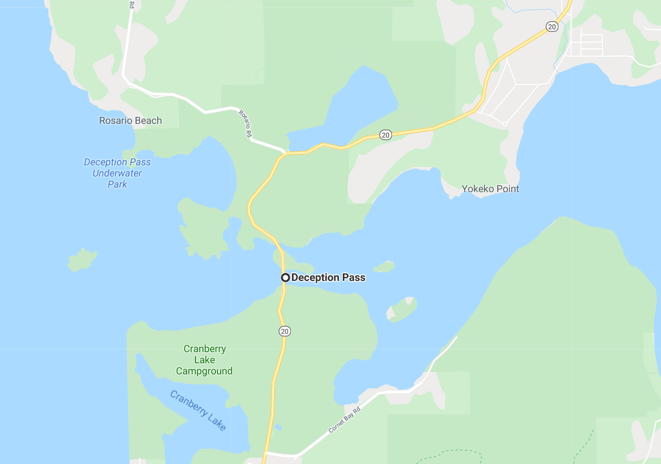
Deception Pass
Mark accompanied us on a fabulous tour of extraordinary places we didn’t know, like Rosario Beach, for example.
Very close to Rosario Beach is Deception Pass, a place that every tourist should visit. There we made an extensive stop and took many videos and photos.
Deception Pass is a strait separating Whidbey Island from Fidalgo Island, in the northwest part of the U.S. state of Washington. It connects Skagit Bay, part of Puget Sound, with the Strait of Juan de Fuca. A pair of bridges known collectively as Deception Pass Bridge cross Deception Pass. The bridges were added to the National Register of Historic Places in 1982.
The Deception Pass area has been home to various Coast Salish tribes for thousands of years. The first Europeans to see Deception Pass were members of the 1790 expedition of Manuel Quimper on the Princesa Real. The Spanish gave it the name Boca de Flon. A group of sailors led by Joseph Whidbey, part of the Vancouver Expedition, found and mapped Deception Pass on June 7, 1792. George Vancouver gave it the name “Deception” because it had misled him into thinking Whidbey Island was a peninsula. The “deception” was heightened due to Whidbey’s failure to find the strait at first. In May 1792, Vancouver was anchored near the southern end of Whidbey Island. He sent Joseph Whidbey to explore the waters east of Whidbey Island, now known as Saratoga Passage, using small boats. Whidbey reached the northern end of Saratoga Passage and explored eastward into Skagit Bay, which is shallow and difficult to navigate. He returned south to rejoin Vancouver without having found Deception Pass. It appeared that Skagit Bay was a dead-end and that Whidbey Island and Fidalgo Island were a long peninsula attached to the mainland. In June the expedition sailed north along the west coast of Whidbey Island. Vancouver sent Joseph Whidbey to explore inlets leading to the east. The first inlet turned out to be a “very narrow and intricate channel, which…abounded with rocks above and beneath the surface of the water”. This channeled to Skagit Bay, thus separating Whidbey Island from the mainland. Vancouver apparently felt he and Joseph Whidbey had been deceived by the tricky strait. Vancouver wrote of Whidbey’s efforts: “This determined [the shore they had been exploring to be an island, which, in consequence of Mr. Whidbey’s circumnavigation, I distinguished by the name of Whidbey’s Island: and this northern pass, leading into [Skagit Bay], Deception Passage”.
In the waters of Deception Pass, just east of the present-day Deception Pass Bridge is a small island known as Ben Ure Island. The island became infamous for its activity of human smuggling of migrant Chinese people for local labor. Ben Ure and his partner Lawrence “Pirate” Kelly were quite profitable at their human smuggling business and played hide-and-seek with the United States Customs Department for years. Ure’s own operation at Deception Pass in the late 1880s consisted of Ure and his Native-American wife. Local tradition has it that his wife would camp on the nearby Strawberry Island (which was visible from the open sea) and signal him with a fire on the island’s summit to alert him to whether or not it was safe to attempt to bring the human cargo he illegally transported ashore. For transport, Ure would tie the people up in burlap bags so that if customs agents were to approach he could easily toss the people in bags overboard. The tidal currents would carry the entrapped drowned migrants’ bodies to San Juan Island to the north and west of the pass and many ended up in what became known as Dead Man’s Bay.
Between the years 1910 and 1914, a prison rock quarry was operated on the Fidalgo Island side of the pass. Nearby barracks housed some 40 prisoners, members of an honors program out of Walla Walla State Penitentiary and the prison population was made up of several types of prisoners, including those convicted of murder. Guards stood to watch at the quarry as the prisoners cut the rock into gravel and loaded it onto barges located at the base of the cliff atop the pass’s waters. The quarried rock was then taken by barge to the Seattle waterfront. The camp was dismantled in 1924 and although abandoned as a quarry, the remains of the camp can still be found. The location, however, is hazardous and over the years there have been several fatal accidents when visitors have ventured onto the steep cliffs.
Upon completion on July 31, 1935, the 976-foot (297 m) span Deception Pass Bridge connected Whidbey Island to the tiny Pass Island, and Pass Island to Fidalgo Island. Prior to the bridge, travelers and businessmen would use an inter-island ferry to commute between Fidalgo and Whidbey islands.
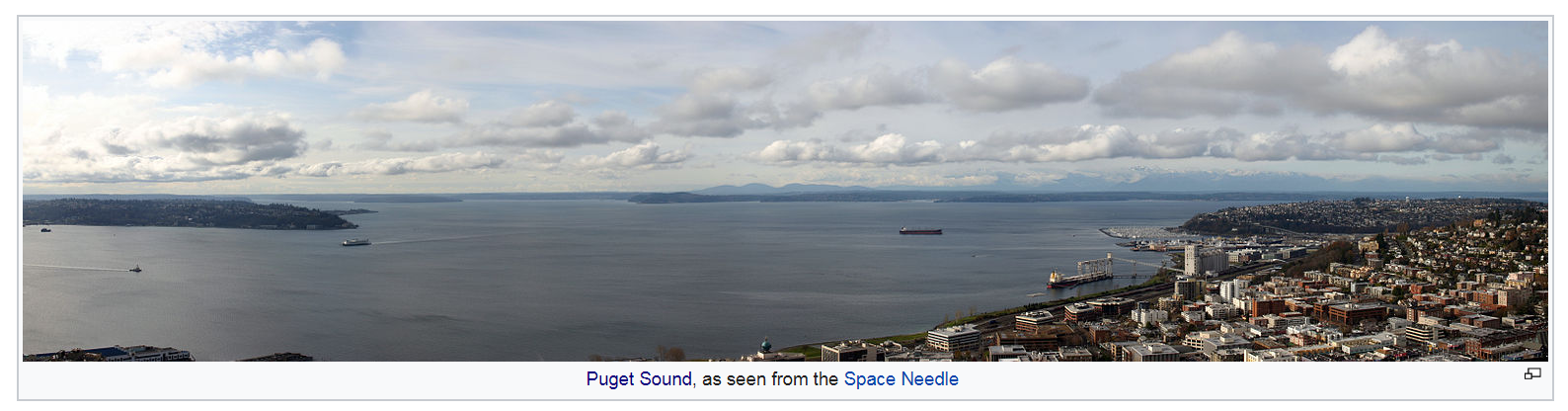
Puget Sound is a sound [an ocean channel] of the Pacific Northwest, an inlet of the Pacific Ocean, and part of the Salish Sea. It is located along the northwestern coast of the U.S. state of Washington. It is a complex estuarine system of interconnected marine waterways and basins, with one major and two minor connections to the open Pacific Ocean via the Strait of Juan de Fuca—Admiralty Inlet being the major connection and Deception Pass and Swinomish Channel being the minor.
Water flow through Deception Pass is approximately equal to 2% of the total tidal exchange between Puget Sound and the Strait of Juan de Fuca. Puget Sound extends approximately 100 miles (160 km) from Deception Pass in the north to Olympia, Washington in the south. Its average depth is 450 feet (140 m) and its maximum depth, off Jefferson Point between Indianola and Kingston, is 930 feet (280 m). The depth of the main basin, between the southern tip of Whidbey Island and Tacoma, Washington, is approximately 600 feet (180 m).
In 2009, the term Salish Sea was established by the United States Board on Geographic Names as the collective waters of Puget Sound, the Strait of Juan de Fuca, and the Strait of Georgia. Sometimes the terms “Puget Sound” and “Puget Sound and adjacent waters” are used for not only Puget Sound proper but also for waters to the north, such as Bellingham Bay and the San Juan Islands region.
The term “Puget Sound” is used not just for the body of water but also for the Puget Sound region centered on the sound. Major cities on the sound include Seattle, Tacoma, Olympia, and Everett, Washington. Puget Sound is also the third-largest estuary in the United States, after the Chesapeake Bay in Maryland and Virginia, and San Francisco Bay in northern California.
In 1792 George Vancouver gave the name “Puget’s Sound” to the waters south of the Tacoma Narrows, in honor of Peter Puget, a Huguenot lieutenant accompanying him on the Vancouver Expedition. This name later came to be used for the waters north of Tacoma Narrows as well.
A different term for Puget Sound, used by a number of Native Americans and environmental groups, is Whulge (or Whulj), an anglicization of the Lushootseed name x̌ʷə́lč, which means “sea, saltwater, ocean, or sound”.
Stevenpass
On our way to Stevenpass, we stopped in a small town to see something incredible: stripper serving coffee. Expresso is very popular in Washington State, and there are sheds selling expresso everywhere. Mark liked to buy his express in this shed where the girls are topless. I wasn’t supposed to take video, but I did it anyway… with al little help from Marky Baby.
In this ski resort, we were able to enjoy the incipient snow. I took a video in which I am promising Miranda to take a snowball. It is a lovely and very picturesque place that we really enjoyed on the way to Wenatchee and finally: Leavenworth.
We started to see snow as soon as we got up in the mountains.
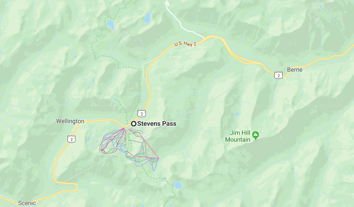
The Stevens Pass Ski Area is a ski area located at the crest of Stevens Pass in the Cascade Range of Washington, United States. The base elevation is at 4,061 feet (1,238 m) with a peak of 5,845 feet (1,782 m). The Mill Valley “backside” of the resort drops to a minimum elevation of 3,821 feet (1,165 m). Total skiable terrain includes 37 major runs covering 1,125 acres (4.55 km2). On August 15th, 2018, Vail Resorts closed on its acquisition of Stevens Pass.
Stevens Pass offers a variety of alpine ski runs ranging from beginner to advanced. Because there is no lodging at the base, Stevens is a day resort drawing heavily on skiers from the Seattle area. Night skiing is offered until 10 pm most days (except Mondays and Tuesdays) during mid-season.
The area is divided into a front (north and east-facing) and back (south-facing) sides.
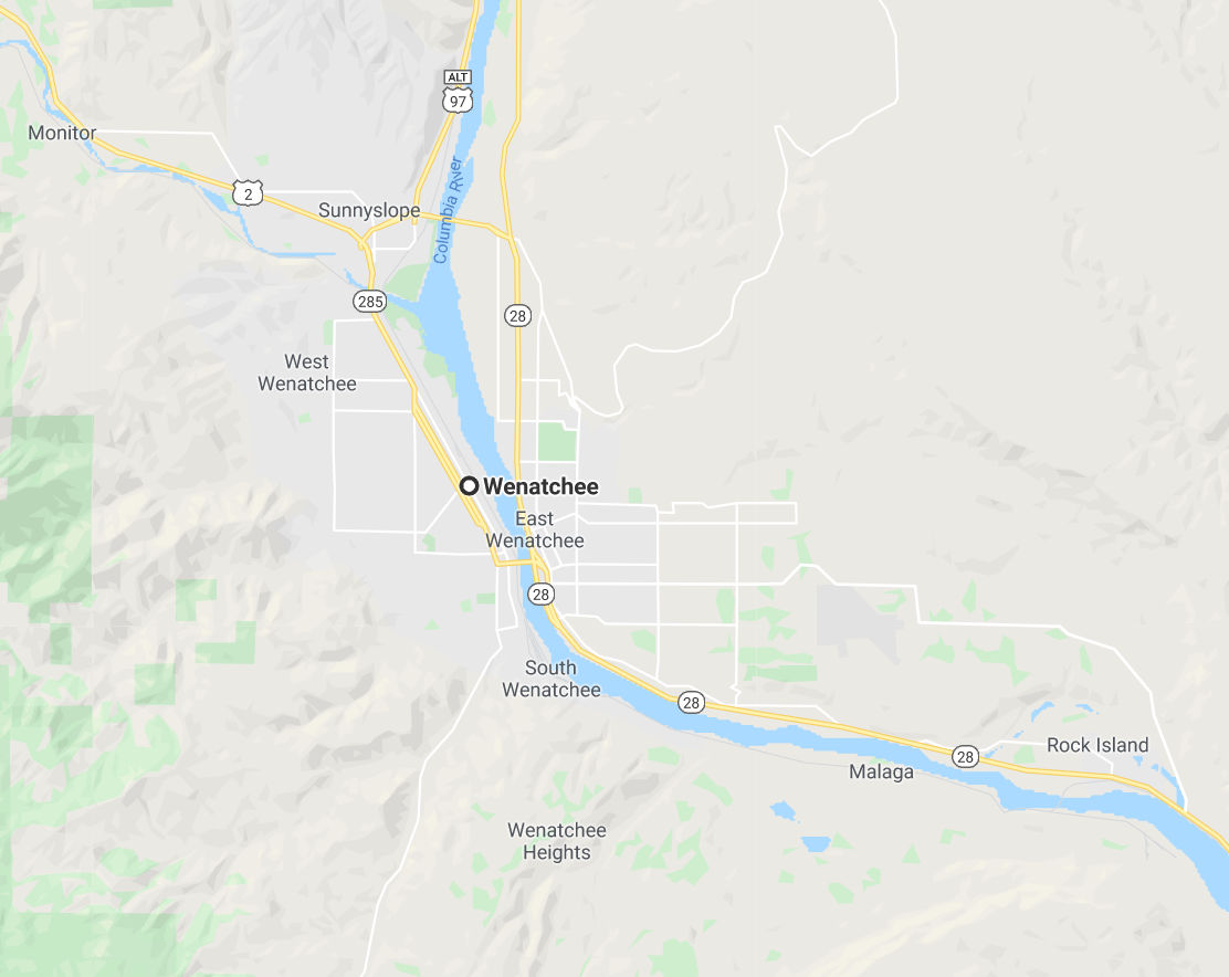
Wenatchee
Walking with Mark the surrounding mountains, we pass the Wenatchee River: a spectacle!
Wenatchee is a city located in north-central Washington and is the largest city and county seat of Chelan County, Washington, United States. The population within the city limits in 2010 was 31,925. In 2018, the Office of Financial Management estimated the population at 34,329. Located at the confluence of the Columbia and Wenatchee rivers near the eastern foothills of the Cascade Range, Wenatchee lies on the western side of the Columbia River, across from the city of East Wenatchee. The Columbia River forms the boundary between Chelan and Douglas County. Wenatchee is the principal city of the Wenatchee–East Wenatchee, Washington Metropolitan Statistical Area, which encompasses all of Chelan and Douglas counties (total population around 110,884). However, the “Wenatchee Valley Area” generally refers to the land between Rocky Reach and Rock Island Dam on both banks of the Columbia, which includes East Wenatchee, Rock Island, and Malaga.
The city was named for the nearby Wenatchi Indian tribe. The name is a Sahaptin word that means “river which comes [or whose source is] from canyons” or “robe of the rainbow”. Wenatchee means “people at the source [of a river]”. The city of Wenatchee shares its name with the Wenatchee River, Lake Wenatchee, and the Wenatchee National Forest.
Wenatchee is referred to as the “Apple Capital of the World” due to the valley’s many orchards. The city is also sometimes referred to as the “Buckle of the Power Belt of the Great Northwest”. The “Power Belt of the Great Northwest” is a metaphor for the series of hydroelectric dams on the Columbia River. Rock Island Dam is located nearest to the middle of this “belt”, and so was labeled the “Buckle”. This saying is printed at the top of every issue of Wenatchee’s newspaper, the Wenatchee World, but is no longer in common use elsewhere.
Archeological digs in nearby East Wenatchee have uncovered Clovis stone and bone tools dating back more than 11,000 years, indicating that people migrating during the last Ice Age spent time in the Wenatchee area. The Columbia River and nearby mountains and sagebrush steppes provided an ample supply of food. Clovis points are on display at the Wenatchee Valley Museum & Cultural Center and research findings are available through the Wenatchee World.
Several indigenous villages existed in the area prior to and during Anglo American exploration. The village Nikwikwi’estku was fishing and gathering camp located in present-day downtown Wenatchee. In 1811, North West Company surveyor David Thompson encountered a group of Native American horsemen at Wenatchee and was invited into a village with huts, the largest measuring 209 feet long. Fur traders document friendly relations through the mid 19th century, even during the smallpox epidemic of 1817 and food shortages in 1841.
During the Yakima War in 1856, US Army Colonel Wright intervened on a possible alliance between Yakama and Wenatchi tribes by removing the Wenatchi to Kittitas. The resulting march was estimated to include 1,000 horses and extend five miles long. A contingent stayed behind to fish at Wenatchapam Fishery in preparation for winter.
In 1863, Father Repair, a Catholic priest, began his missionary work with the Indians. He was followed some 20 years later by Father De Grassi, who built a log cabin on the Wenatchee River near the present town of Cashmere. Throughout the 19th century, other white settlers came to homestead the land. Wenatchee was platted in September 1888 and officially incorporated as a city on January 7, 1893. The 1900 U.S. Census counted 451 residents.
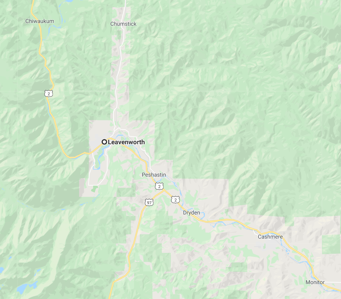
Leavenworth
We really enjoyed the visit to Leavenworth. It reminded us a lot of La Colonia Tovar in Venezuela
Photos of Colonia Tovar
It is a town in the purest German style. There we had an exquisite German meal and toured the place taking many videos and photos. It was worth the trip.
Coming back was danger. We had to drive at night and through the snow. Thank God that Mark is as good as a driver as his late father – Norman – was.
Leavenworth is a city in Chelan County, Washington, United States. It is part of the Wenatchee−East Wenatchee Metropolitan Statistical Area. The population was 1,965 at the 2010 census. The entire town center is modeled on a Bavarian village as part of a civic initiative that began in the 1960s. The area is a major tourist destination during the wintertime. The railroad construction was completed during the winter of 1893. Lafayette Lamb arrived in 1903 from Clinton, Iowa to build the second largest sawmill in Washington state.
Leavenworth was officially incorporated on September 5, 1906. A small timber community, it became the headquarters of the Great Northern Railway in the early 1900s. The railroad relocated to Wenatchee in the 1920s, greatly affecting Leavenworth’s economy.
In 1962, the Project LIFE (Leavenworth Improvement For Everyone) Committee was formed in partnership with the University of Washington to investigate strategies to revitalize the struggling logging town. The theme town idea was created by two Seattle businessmen, Ted Price and Bob Rodgers, who had bought a failing cafe on Highway 2 in 1960. Price was chair of the Project LIFE tourism subcommittee, and in 1965 the pair led a trip to a Danish-themed town, Solvang, California, to build support for the idea. The first building to be remodeled in the Bavarian style was the Chikamin Hotel, which owner Jamie Peterson renamed the Edelweiss after the state flower of Bavaria.
Leavenworth is home to the Leavenworth Nutcracker Museum, which opened in 1995 and contains more than 5,000 nutcrackers dating from prehistoric to modern. Leavenworth hosts an annual Oktoberfest celebration. Leavenworth’s transformation into a theme town was inspired, and assisted, by Solvang, California. Later, the Washington town of Winthrop followed Leavenworth’s example and adopted a Western town theme.
In November 2007, Good Morning America went to Leavenworth for Holiday Gifts for the Globe where GMA helped light up the town for the Christmas Holiday. Leavenworth was also named the Ultimate Holiday Town USA by A&E.
Coupeville
On the way to Copuperville, we pass through several interesting places, such as Rosario Beach and Deception Pass
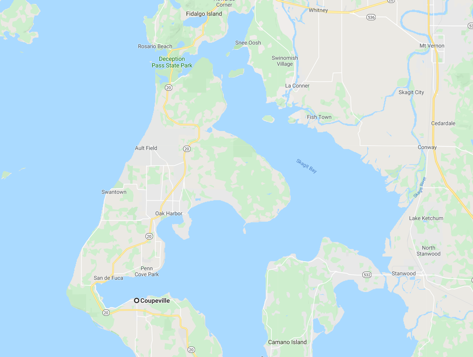
In this small town, Mark’s wife, Sheryl, lived a large part of his teenage life. A very interesting place that transported us to the 30s. There we had a wonderful lunch and we were able to walk its few streets full of shops for tourists.
Coupeville is a town on Whidbey Island, in Island County, Washington, United States. It is the county seat of Island County. The population was 1,831 at the 2010 census. Coupeville was laid out in the 1850s by Captain Thomas Coupe, and named for him. Coupeville was officially incorporated on April 20, 1910.
Coupeville is a historic district is within the federal Ebey’s Landing National Historical Reserve. The reserve was established by Congress in 1978 as the first and only National Historical Reserve in the nation. It’s 22 square miles (57 km2) also encompass farmlands, Fort Ebey State Park, Fort Casey State Park, shorelines and beaches, parks, trails, and 91 buildings and structures on the National Register of Historic Places.
Fort Casey
We pass through Fort Casey where, in reality, there is not much to see, but it is a must for the return to Snohomish.
Fort Casey State Park is located on Whidbey Island, in Island County, Washington state. It is a Washington state park and a historic district within the U.S. Ebey’s Landing National Historical Reserve.
Admiralty Inlet was considered so strategic to the defense of Puget Sound in the 1890s that three forts — Fort Casey on Whidbey Island, Fort Flagler on Marrowstone Island, and Fort Worden at Port Townsend — were built with the intention to create a “triangle of fire” against invading ships. This military strategy was based on the theory that the three fortresses would thwart any invasion attempt by sea.
Fort Casey was named for Brigadier General Thomas Lincoln Casey, U.S. Army Chief of Engineers. Designed as part of the massive modernization program of U.S. seacoast fortifications initiated by the Endicott Board, construction on Fort Casey began in 1897. In 1901, the big guns on disappearing carriages, which could be raised out of their protective emplacements so that the guns were exposed only long enough to fire, became active. However, the fort’s batteries became obsolete almost as soon as their construction was completed.
The invention of the airplane in 1903 and the subsequent development of military aircraft made the fort vulnerable to air attack. In addition, the development of battleships designed with increasingly accurate weaponry transformed the static strategies of the nineteenth century into the more mobile attack systems of the twentieth century.
Most of Fort Casey’s guns and mortars were removed during World War I when they were mounted on railcars to serve as mobile heavy artillery. Some of these weapons were returned to the fort after the war and were scrapped during World War II as 16-inch guns and other weapons at other forts superseded them.
The two 10-inch guns on disappearing carriages currently mounted at Fort Casey were transferred from the Philippines in the 1960s, along with two three-inch guns. The 10-inch guns are M1895MI (No. 26 and No. 28 Watervliet) on disappearing carriages M1901 (No. 13 and No. 15 Watertown) at Battery Worth, Fort Casey (originally at Battery Warwick, Fort Wint, Grande Island, Philippines). The three-inch guns are M1903 (No. 11 and No. 12) on barbette carriages M1903 (No. 6 and No. 7) at Battery Trevor, Fort Casey (originally at Battery Flake, Fort Wint).
Keystone
Mark took us to Keystone. From Keystone, we took a ferry that returned us to the mainland.
Keystone is a small unincorporated community on Whidbey Island in Island County, Washington, in the northwestern United States. It is near the Coupeville Ferry Landing, a dock for the Washington State Ferries route to Port Townsend that provides a maritime link for State Route 20 across Admiralty Inlet. It is located about 3 miles due south of Coupeville near Fort Casey State Park and Ebey’s Prairie National Historic Preserve.
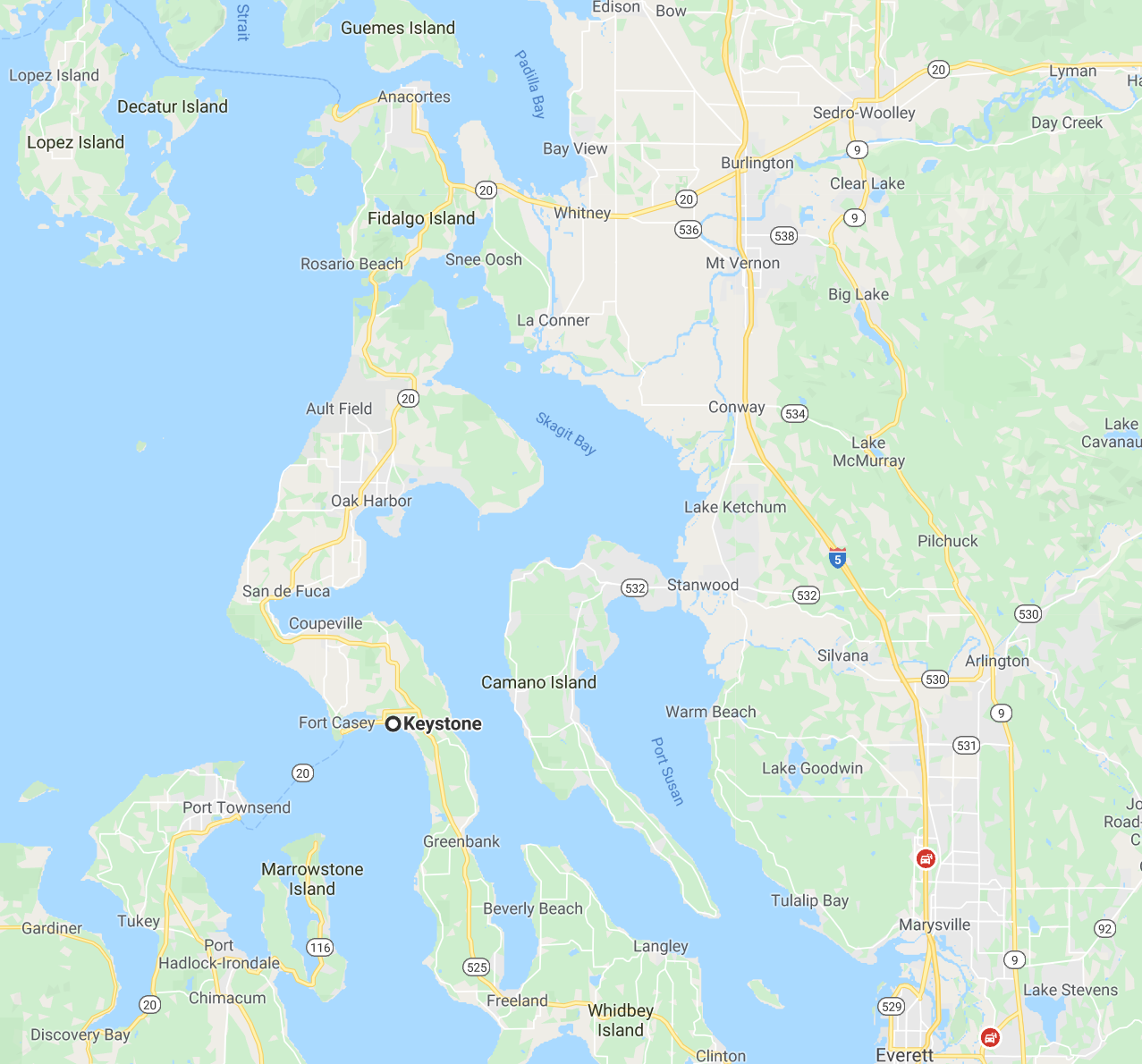
Onalaska
The Losh family moved from Deer Park and landed in a small town called “Onalaska.” There they set up a homemade restaurant and lived many years. When we left Venezuela, in 2004, we spent a few weeks in “Onalaska”. 13 years later, we returned to that little town and toured it. We visited the house that was Losh and spent a day with Sharon, who lives a few miles from the small town.
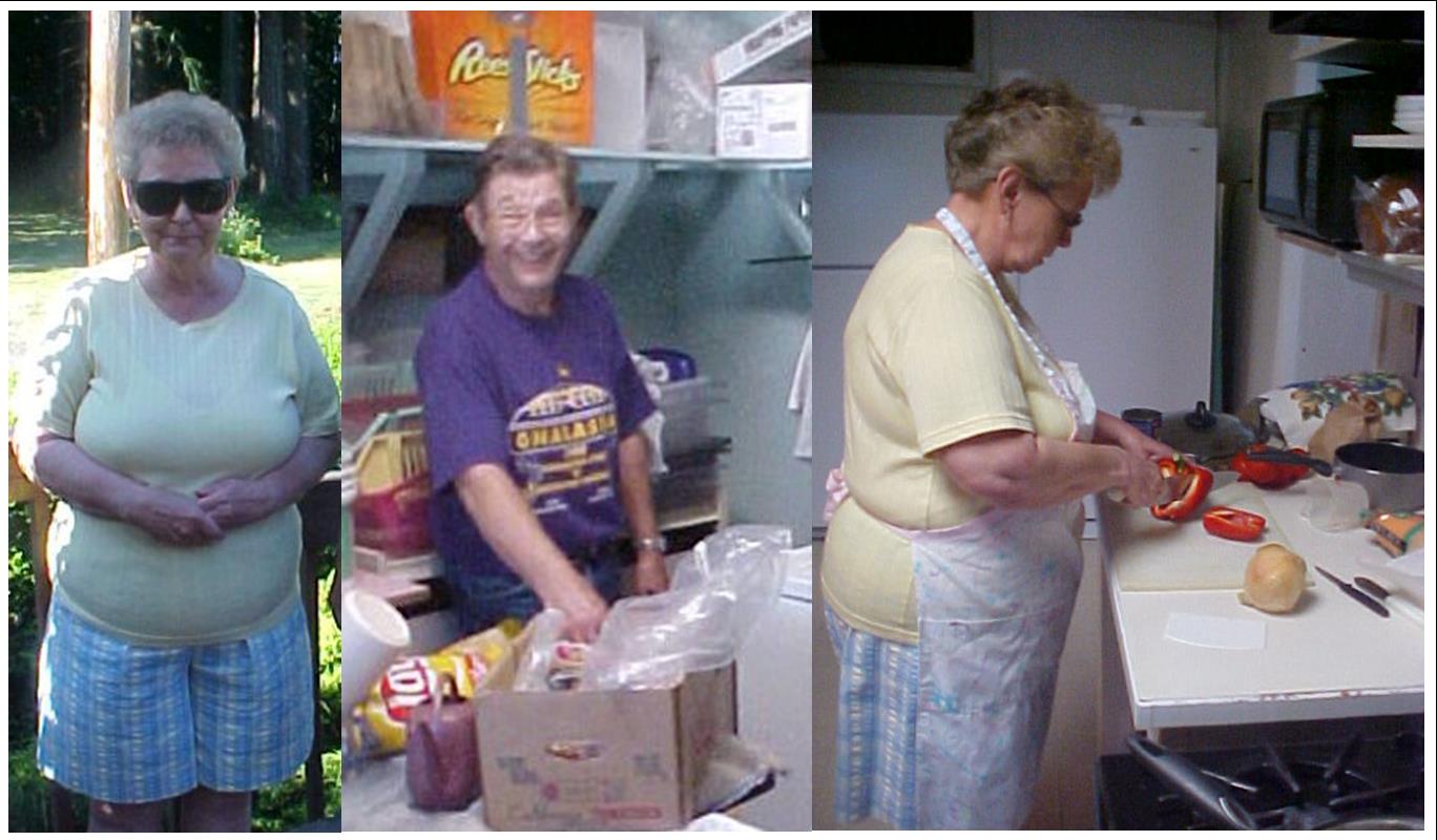
Beverly & Norman in Onalaska – 2004
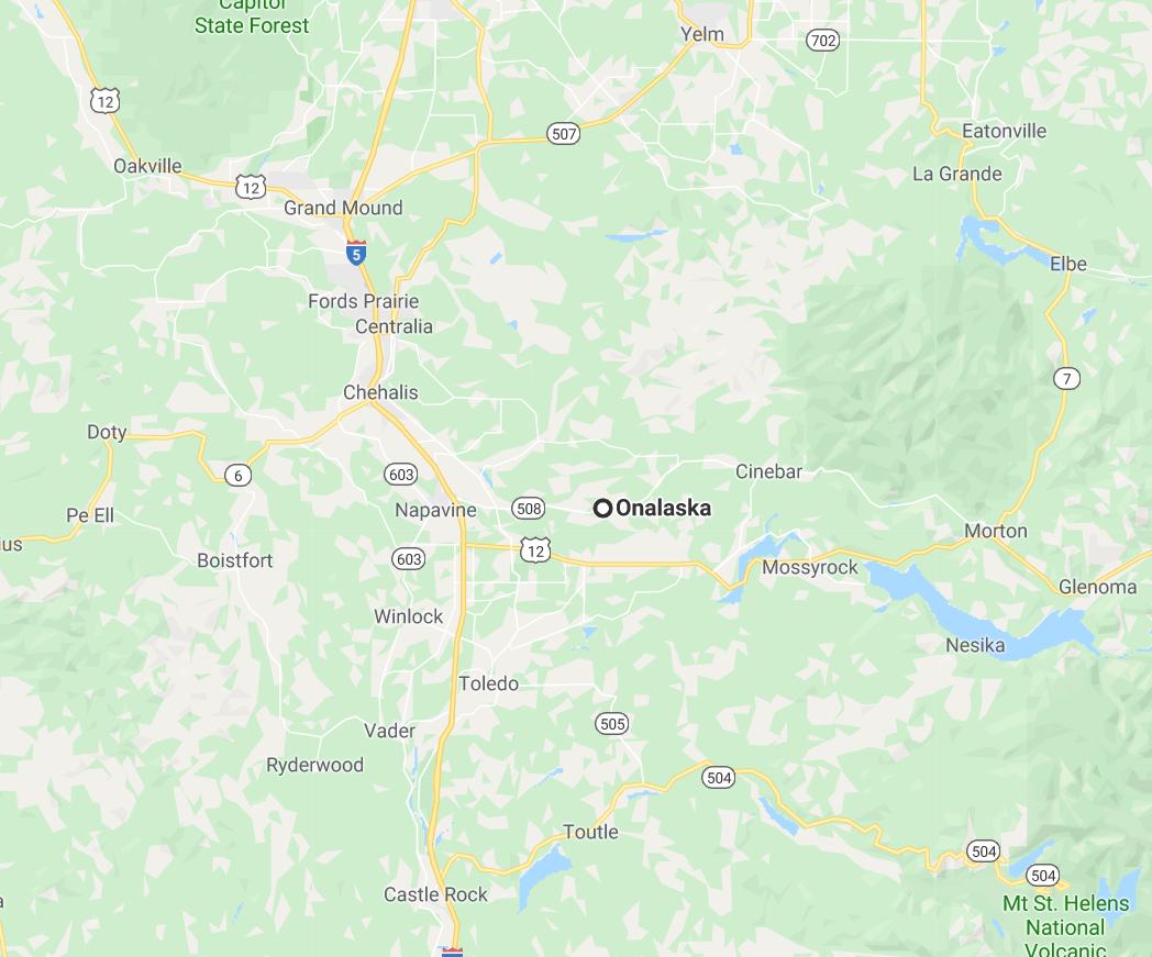
We took a video of old Deer Park pictures
The Bower’s house is fabulous: spectacular! There I came across the piano that was in the basement of the house in Deer Park, where I practically learned to play it. Of course I gave them a small concert.
Sharon asked me to play the favorite song of her late father, Norman: Tennessee Waltz.
Sharon took us to the “Onalaska” store, which was not the same one we had known in 2004, anyway it was interesting to visit it
Onalaska is an unincorporated community and census-designated place in Lewis County, Washington, United States. Onalaska is located along Washington State Route 508. Onalaska has a post office with ZIP code 98570.
The name for the community comes from the poem, “The Pleasures of Hope” by Scottish poet Thomas Campbell. Onalaska, Washington, Onalaska, Wisconsin, Onalaska, Arkansas and Onalaska, Texas are all historically connected to one another through the lumber industry.
Onalaska was built around the inland mill established by the Carlisle Lumber Company in 1909. The smokestack near Carlisle Lake is the last trace of one of the most successful mid-sized sawmills in Washington State. At its peak in 1929, company inventory numbered over 20 million board feet of lumber — enough to stretch all the way to the Panama Canal.
The mill employed a sizeable number of Japanese and Japanese Americans. They lived north of today’s State Route 508 and east of Carlisle Avenue. The streets, which ran parallel to Carlisle Avenue were called Oriental Avenue, Nippon Avenue and Tokyo Avenue.
According to “Onalaska”, a history of the Carlisle Lumber Company by Vic Kucera the 1940 census showed 62 people of Japanese descent living in Lewis County. Because of their experience in the mill, the local Japanese-Americans were sent to directly to Tulelake camp in California to help with its construction, Kucera writes. The Army needed their help to finish the camp where they would spend the war.
The Lewis County Museum in Chehalis has an exhibit honoring the Japanese and Japanese American internees.
Oregon
Just as we arrived at Washington State, we returned via the state of Oregon, where I was amazed by a musical group called “Jellyroll Society”, whose music I used in many of the edited videos of this trip.
Oregon is a state in the Pacific Northwest region on the West Coast of the United States. The Columbia River delineates much of Oregon’s northern boundary with Washington, while the Snake River delineates much of its eastern boundary with Idaho. The parallel 42° north delineates the southern boundary with California and Nevada.
Oregon was inhabited by many indigenous tribes before European traders, explorers, and settlers arrived. An autonomous government was formed in the Oregon Country in 1843 before the Oregon Territory was created in 1848. Oregon became the 33rd state on February 14, 1859. Today, at 98,000 square miles (250,000 km2), Oregon is the ninth largest and, with a population of 4 million, 27th most populous U.S. state. The capital, Salem, is the second-most populous city in Oregon, with 169,798 residents. Portland, with 647,805, ranks as the 26th among U.S. cities. The Portland metropolitan area, which also includes the city of Vancouver, Washington, to the north, ranks the 25th largest metro area in the nation, with a population of 2,453,168.
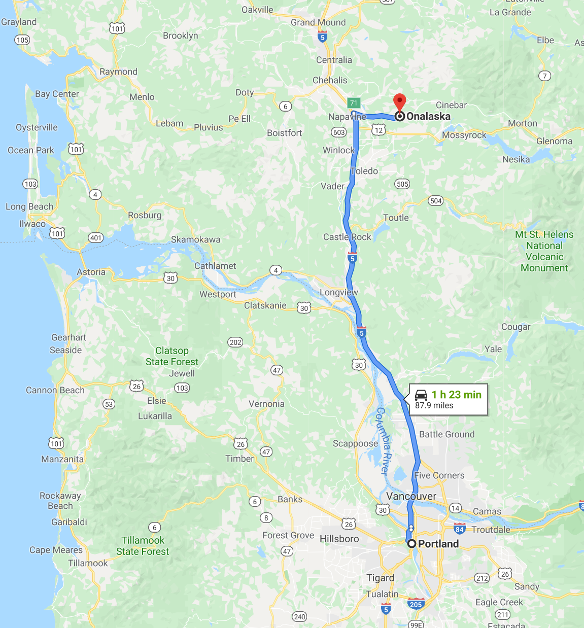
Oregon is one of the most geographically diverse states in the U.S., marked by volcanoes, abundant bodies of water, dense evergreen and mixed forests, as well as high deserts and semi-arid shrublands. At 11,249 feet (3,429 m), Mount Hood, a stratovolcano, is the state’s highest point. Oregon’s only national park, Crater Lake National Park, comprises the caldera surrounding Crater Lake, the deepest lake in the United States. The state is also home to the single largest organism in the world, Armillaria ostoyae, a fungus that runs beneath 2,200 acres (8.9 km2) of the Malheur National Forest.
Because of its diverse landscapes and waterways, Oregon’s economy is largely powered by various forms of agriculture, fishing, and hydroelectric power. Oregon is also the top timber producer of the contiguous United States, and the timber industry dominated the state’s economy in the 20th century. Technology is another one of Oregon’s major economic forces, beginning in the 1970s with the establishment of the Silicon Forest and the expansion of Tektronix and Intel. Sportswear company Nike, Inc., headquartered in Beaverton, is the state’s largest public corporation with annual revenue of $30.6 billion.
Houston
Returning to Florida from the state of Oregon, we stopped at the Houston airport, where we had two Bloody Maries and some sandwiches that were delicious. We ordered everything through a “robot”, as there were no waiters to take the order. We found that worrisome. Every day the world will no longer need the participation of human beings. Of course, it was always required of a person who brought us what was ordered. We made the payment through the “robot” with our debit card.
Houston (/ˈhjuːstən/ ( listen) HEW-stən) is the most populous city in the U.S. state of Texas, a fourth-most populous city in the United States, as well as the sixth most populous in North America, with an estimated 2018 population of 2,325,502. Located in Southeast Texas near Galveston Bay and the Gulf of Mexico, it is the seat of Harris County and the principal city of the Greater Houston metropolitan area, which is the fifth most populous metropolitan statistical area in the United States and the second-most populous in Texas after the Dallas-Fort Worth metroplex, with a population of 6,997,384 in 2018.
Comprising a total area of 637.4 square miles (1,651 km2), Houston is the eighth most expansive city in the United States (including consolidated city-counties). It is the largest city in the United States by total area, whose government is not consolidated with that of a county, parish or borough. Though primarily in Harris County, small portions of the city extend into Fort Bend and Montgomery counties, bordering other principal communities of Greater Houston such as Sugar Land and The Woodlands.
The city of Houston was founded by land investors on August 30, 1836, at the confluence of Buffalo Bayou and White Oak Bayou (a point now known as Allen’s Landing) and incorporated as a city on June 5, 1837. The city is named after former General Sam Houston, who was president of the Republic of Texas and had won Texas’ independence from Mexico at the Battle of San Jacinto 25 miles (40 km) east of Allen’s Landing. After briefly serving as the capital of the Texas Republic in the late 1830s, Houston grew steadily into a regional trading center for the remainder of the 19th century.
The arrival of the 20th century saw a convergence of economic factors which fueled rapid growth in Houston, including a burgeoning port and railroad industry, the decline of Galveston as Texas’ primary port following a devastating 1900 hurricane, the subsequent construction of the Houston Ship Channel, and the Texas oil boom. In the mid-20th century, Houston’s economy diversified as it became home to the Texas Medical Center—the world’s largest concentration of healthcare and research institutions—and NASA’s Johnson Space Center, where the Mission Control Center is located.
Houston’s economy since the late 20th century has a broad industrial base in energy, manufacturing, aeronautics, and transportation. Leading in healthcare sectors and building oilfield equipment, Houston has the second most Fortune 500 headquarters of any U.S. municipality within its city limits (after New York City). The Port of Houston ranks first in the United States in international waterborne tonnage handled and second in total cargo tonnage handled. Nicknamed the “Bayou City” “Space City”, “H-Town”, and “the 713”, Houston has become a global city, with strengths in culture, medicine, and research. The city has a population of various ethnic and religious backgrounds and a large and growing international community. Houston is the most diverse metropolitan area in Texas and has been described as the most racially and ethnically diverse major metropolis in the U.S.[ It is home to many cultural institutions and exhibits, which attract more than 7 million visitors a year to the Museum District. Houston has an active visual and performing arts scene in the Theater District and offers year-round resident companies in all major performing arts.
Fort Lauderdale
Finally, we flew back home, from Portland [Oregon] to Ft. Lauderdale. As we waited for our luggage, we sat next to this Mexican who was high on something. He was talking on his cell and while he taled he laughed and cried out loud. It was weird and funny at the same time.